Benkovac geodata
Benkovac (Zadarska) is a seat of a second-order administrative division; located in Croatia in Europe/Zagreb (GMT+2) time zone. With population of 2,635 people, there are 164 cities with bigger population in this country. Compared to other cities in Croatia, 83.8% of cities are located further ↑North; 81.2% of cities are located further →East and 75.4% of cities have lower elevation than Benkovac. Note1


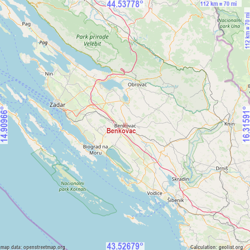
Benkovac GPS coordinates[2]
44° 2' 3.984" North, 15° 36' 46.008" East
| Map corner | latitude | longitude |
|---|---|---|
| Upper-left | 44.53778°, | 14.90966° |
| Center: | 44.03444°, | 15.61278° |
| Lower-right: | 43.52679°, | 16.31591° |
| Map W x H: | 112.4×112.4 km | = 69.8×69.8mi |
| max Lat: | 46.52694° ⇑83.8% North |
| Benkovac: | 44.03444° |
| min Lat: | ⇓16.2% South 42.54972° |
| min Long | Benkovac | max Long |
| 13.52389° | 15.61278° | 19.37694° |
| W 18.8%⇐ | ⇒81.2% E |
Elevation
Elevation of Benkovac is 180 m = 591 ft, and this is 26.7 m = 88 ft above average elevation for this country.
| Max E: |
827 m = 2713 ft | 24.6% |
| Benkovac | 180 m 591 ft | |
| Avg. | 153.3 m = 503 ft | |
Min E: |
-1 m = -3 ft | 75.4% |
See also: Croatia elevation on elevation.city.
Geographical zone
Benkovac is located in North temperate zone (between Tropic of Cancer and the Arctic Circle). Distance of this Northern Tropic circle is 2290.3 km =1423.1 mi to South.| Distance of | km | miles | from Benkovac |
|---|---|---|---|
| North Pole | 5110.9 | 3175.8 | to North |
| Arctic Circle | 2505 | 1556.5 | to North |
| Tropic Cancer | 2290.3 | 1423.1 | to South |
| Equator | 4896.2 | 3042.4 | to South |


Nearby cities:
15 places around Benkovac: (largest is in red/bold)
• Biograd na Moru
16.4 km =10.2 mi,  231°
231°
• Buković
1.6 km =1 mi,  94°
94°
• Drage
17.1 km =10.6 mi,  199°
199°
• Gornji Karin
11.4 km =7.1 mi,  8°
8°
• Kruševo
16.8 km =10.4 mi, 10°
• Lišane Ostrovičke
14.8 km =9.2 mi,  119°
119°
• Novigrad
17.3 km =10.7 mi,  344°
344°
• Pakoštane
15.9 km =9.9 mi,  211°
211°
• Polača
7.8 km =4.8 mi,  256°
256°
• Pridraga
15.2 km =9.4 mi,  345°
345°
• Stankovci
15.5 km =9.6 mi,  153°
153°
• Sveti Filip i Jakov
16.5 km =10.3 mi,  242°
242°
• Tinj
11.2 km =7 mi, 261°
• Vukšić
13.5 km =8.4 mi,  138°
138°
• Škabrnje
14.2 km =8.8 mi,  296°
296°
Sources, notices
• [Note1] Compared only with cities in Croatia existing in our database
• [Src1] Map data: © OpenStreetMap contributors (CC-BY-SA)
• [Src2] Other city data from geonames.org with taken over terms of usage.
• [Src3] Geographical zone / Annual Mean Temperature by Robert A. Rohde @ Wikipedia
