Kruševo geodata
Kruševo (Zadarska) is a populated place; located in Croatia in Europe/Zagreb (GMT+2) time zone. With population of 1,112 people, there are 412 cities with bigger population in this country. Compared to other cities in Croatia, 81.3% of cities are located further ↑North; 80.4% of cities are located further →East and 83.4% of cities have lower elevation than Kruševo. Note1


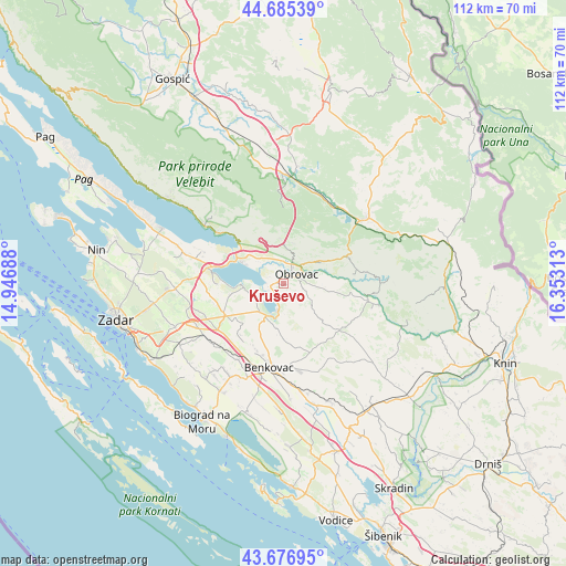
Kruševo GPS coordinates[2]
44° 10' 59.988" North, 15° 39' 0" East
| Map corner | latitude | longitude |
|---|---|---|
| Upper-left | 44.68539°, | 14.94688° |
| Center: | 44.18333°, | 15.65° |
| Lower-right: | 43.67695°, | 16.35313° |
| Map W x H: | 112.1×112.1 km | = 69.7×69.7mi |
| max Lat: | 46.52694° ⇑81.3% North |
| Kruševo: | 44.18333° |
| min Lat: | ⇓18.7% South 42.54972° |
| min Long | Kruševo | max Long |
| 13.52389° | 15.65° | 19.37694° |
| W 19.6%⇐ | ⇒80.4% E |
Elevation
Elevation of Kruševo is 227 m = 745 ft, and this is 73.7 m = 242 ft above average elevation for this country.
| Max E: |
827 m = 2713 ft | 16.6% |
| Kruševo | 227 m 745 ft | |
| Avg. | 153.3 m = 503 ft | |
Min E: |
-1 m = -3 ft | 83.4% |
See also: Croatia elevation on elevation.city.
Geographical zone
Kruševo is located in North temperate zone (between Tropic of Cancer and the Arctic Circle). Distance of this Northern Tropic circle is 2306.8 km =1433.4 mi to South.| Distance of | km | miles | from Kruševo |
|---|---|---|---|
| North Pole | 5094.3 | 3165.5 | to North |
| Arctic Circle | 2488.4 | 1546.2 | to North |
| Tropic Cancer | 2306.8 | 1433.4 | to South |
| Equator | 4912.7 | 3052.6 | to South |


Nearby cities:
15 places around Kruševo: (largest is in red/bold)
• Benkovac
16.8 km =10.4 mi,  190°
190°
• Buković
16.7 km =10.4 mi,  184°
184°
• Gornji Karin
5.4 km =3.4 mi, 193°
• Gračac
20.3 km =12.6 mi,  50°
50°
• Jesenice
7.8 km =4.8 mi,  311°
311°
• Novigrad
7.6 km =4.7 mi,  270°
270°
• Obrovac
3.2 km =2 mi, 53°
• Podgradina
12.9 km =8 mi, 270°
• Polača
21.2 km =13.2 mi,  209°
209°
• Posedarje
14.2 km =8.8 mi,  283°
283°
• Pridraga
6.9 km =4.3 mi,  254°
254°
• Slivnica
17.4 km =10.8 mi,  292°
292°
• Starigrad
21 km =13 mi, 306°
• Suhovare
19.6 km =12.2 mi,  261°
261°
• Škabrnje
18.7 km =11.6 mi,  236°
236°
Sources, notices
• [Note1] Compared only with cities in Croatia existing in our database
• [Src1] Map data: © OpenStreetMap contributors (CC-BY-SA)
• [Src2] Other city data from geonames.org with taken over terms of usage.
• [Src3] Geographical zone / Annual Mean Temperature by Robert A. Rohde @ Wikipedia
