Murter geodata
Murter (Šibensko-Kniniska) is a seat of a second-order administrative division; located in Croatia in Europe/Zagreb (GMT+2) time zone. With population of 2,078 people, there are 203 cities with bigger population in this country. Compared to other cities in Croatia, 85.9% of cities are located further ↑North; 81.5% of cities are located further →East and 99.5% of cities have higher elevation than Murter. Note1


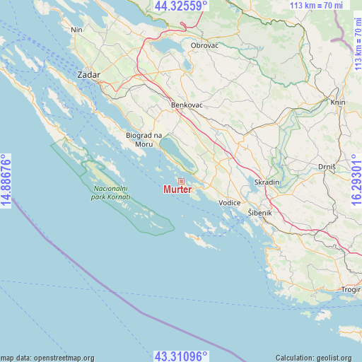
Murter GPS coordinates[2]
43° 49' 13.548" North, 15° 35' 23.568" East
| Map corner | latitude | longitude |
|---|---|---|
| Upper-left | 44.32559°, | 14.88676° |
| Center: | 43.82043°, | 15.58988° |
| Lower-right: | 43.31096°, | 16.29301° |
| Map W x H: | 112.8×112.8 km | = 70.1×70.1mi |
| max Lat: | 46.52694° ⇑85.9% North |
| Murter: | 43.82043° |
| min Lat: | ⇓14.1% South 42.54972° |
| min Long | Murter | max Long |
| 13.52389° | 15.58988° | 19.37694° |
| W 18.5%⇐ | ⇒81.5% E |
Elevation
Elevation of Murter is 1 m = 3 ft, and this is 152.3 m = 500 ft below average elevation for this country.
| Max E: |
827 m = 2713 ft | 99.5% |
| Avg. | 153.3 m = 503 ft | |
| Murter | 1 m = 3 ft | |
Min E: |
-1 m = -3 ft | 0.5% |
See also: Croatia elevation on elevation.city.
Geographical zone
Murter is located in North temperate zone (between Tropic of Cancer and the Arctic Circle). Distance of this Northern Tropic circle is 2266.5 km =1408.3 mi to South.| Distance of | km | miles | from Murter |
|---|---|---|---|
| North Pole | 5134.7 | 3190.6 | to North |
| Arctic Circle | 2528.8 | 1571.3 | to North |
| Tropic Cancer | 2266.5 | 1408.3 | to South |
| Equator | 4872.4 | 3027.6 | to South |


Nearby cities:
15 places around Murter: (largest is in red/bold)
• Biograd na Moru
17.6 km =10.9 mi,  321°
321°
• Drage
8.6 km =5.3 mi,  332°
332°
• Jezera
5.5 km =3.4 mi,  131°
131°
• Pakoštane
12.1 km =7.5 mi, 327°
• Pirovac
6.7 km =4.2 mi,  91°
91°
• Raslina
21.3 km =13.2 mi, 94°
• Srima
19.1 km =11.9 mi,  115°
115°
• Stankovci
13.3 km =8.3 mi,  41°
41°
• Sveti Filip i Jakov
20.5 km =12.7 mi, 321°
• Tisno
4.7 km =2.9 mi,  112°
112°
• Tkon
17.5 km =10.9 mi,  308°
308°
• Tribunj
14.4 km =8.9 mi, 120°
• Vodice
16.8 km =10.4 mi, 113°
• Vukšić
17.5 km =10.9 mi, 38°
• Zaton
19.2 km =11.9 mi,  100°
100°
Sources, notices
• [Note1] Compared only with cities in Croatia existing in our database
• [Src1] Map data: © OpenStreetMap contributors (CC-BY-SA)
• [Src2] Other city data from geonames.org with taken over terms of usage.
• [Src3] Geographical zone / Annual Mean Temperature by Robert A. Rohde @ Wikipedia
