Pakoštane geodata
Pakoštane (Zadarska) is a seat of a second-order administrative division; located in Croatia in Europe/Zagreb (GMT+2) time zone. With population of 2,123 people, there are 195 cities with bigger population in this country. Compared to other cities in Croatia, 85.3% of cities are located further ↑North; 82.5% of cities are located further →East and 92% of cities have higher elevation than Pakoštane. Note1


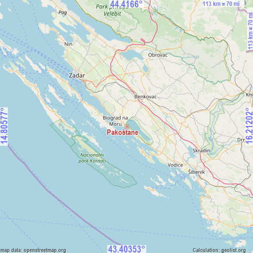
Pakoštane GPS coordinates[2]
43° 54' 43.992" North, 15° 30' 32.004" East
| Map corner | latitude | longitude |
|---|---|---|
| Upper-left | 44.4166°, | 14.80577° |
| Center: | 43.91222°, | 15.50889° |
| Lower-right: | 43.40353°, | 16.21202° |
| Map W x H: | 112.6×112.6 km | = 70×70mi |
| max Lat: | 46.52694° ⇑85.3% North |
| Pakoštane: | 43.91222° |
| min Lat: | ⇓14.7% South 42.54972° |
| min Long | Pakoštane | max Long |
| 13.52389° | 15.50889° | 19.37694° |
| W 17.5%⇐ | ⇒82.5% E |
Elevation
Elevation of Pakoštane is 16 m = 52 ft, and this is 137.3 m = 450 ft below average elevation for this country.
| Max E: |
827 m = 2713 ft | 92% |
| Avg. | 153.3 m = 503 ft | |
| Pakoštane | 16 m = 52 ft | |
Min E: |
-1 m = -3 ft | 8% |
See also: Croatia elevation on elevation.city.
Geographical zone
Pakoštane is located in North temperate zone (between Tropic of Cancer and the Arctic Circle). Distance of this Northern Tropic circle is 2276.7 km =1414.7 mi to South.| Distance of | km | miles | from Pakoštane |
|---|---|---|---|
| North Pole | 5124.5 | 3184.2 | to North |
| Arctic Circle | 2518.6 | 1565 | to North |
| Tropic Cancer | 2276.7 | 1414.7 | to South |
| Equator | 4882.6 | 3033.9 | to South |


Nearby cities:
15 places around Pakoštane: (largest is in red/bold)
• Benkovac
15.9 km =9.9 mi,  31°
31°
• Biograd na Moru
5.7 km =3.5 mi,  307°
307°
• Buković
16.7 km =10.4 mi,  36°
36°
• Drage
3.6 km =2.2 mi,  134°
134°
• Jezera
17.4 km =10.8 mi,  142°
142°
• Murter
12.1 km =7.5 mi,  147°
147°
• Pašman
11.1 km =6.9 mi,  296°
296°
• Pirovac
16.7 km =10.4 mi, 128°
• Polača
11.8 km =7.3 mi,  3°
3°
• Stankovci
15.3 km =9.5 mi,  91°
91°
• Sveti Filip i Jakov
8.6 km =5.3 mi, 312°
• Tinj
12.2 km =7.6 mi,  346°
346°
• Tisno
16.1 km =10 mi, 138°
• Tkon
7.2 km =4.5 mi,  275°
275°
• Turanj
10.2 km =6.3 mi, 309°
Sources, notices
• [Note1] Compared only with cities in Croatia existing in our database
• [Src1] Map data: © OpenStreetMap contributors (CC-BY-SA)
• [Src2] Other city data from geonames.org with taken over terms of usage.
• [Src3] Geographical zone / Annual Mean Temperature by Robert A. Rohde @ Wikipedia
