Drage geodata
Drage (Zadarska) is a populated place; located in Croatia in Europe/Zagreb (GMT+2) time zone. With population of 893 people, there are 531 cities with bigger population in this country. Compared to other cities in Croatia, 85.6% of cities are located further ↑North; 82.2% of cities are located further →East and 88% of cities have higher elevation than Drage. Note1


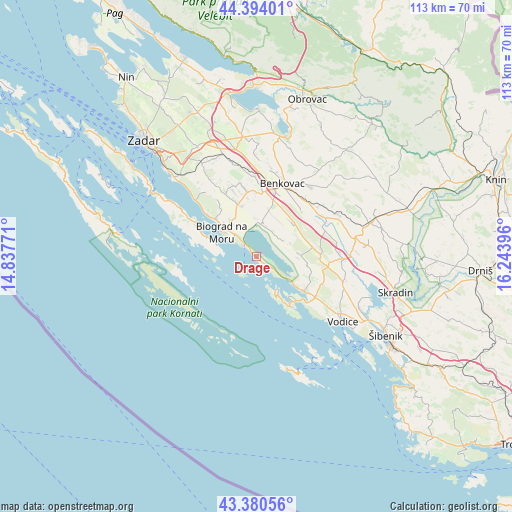
Drage GPS coordinates[2]
43° 53' 21.984" North, 15° 32' 26.988" East
| Map corner | latitude | longitude |
|---|---|---|
| Upper-left | 44.39401°, | 14.83771° |
| Center: | 43.88944°, | 15.54083° |
| Lower-right: | 43.38056°, | 16.24396° |
| Map W x H: | 112.7×112.7 km | = 70×70mi |
| max Lat: | 46.52694° ⇑85.6% North |
| Drage: | 43.88944° |
| min Lat: | ⇓14.4% South 42.54972° |
| min Long | Drage | max Long |
| 13.52389° | 15.54083° | 19.37694° |
| W 17.8%⇐ | ⇒82.2% E |
Elevation
Elevation of Drage is 33 m = 108 ft, and this is 120.3 m = 395 ft below average elevation for this country.
| Max E: |
827 m = 2713 ft | 88% |
| Avg. | 153.3 m = 503 ft | |
| Drage | 33 m = 108 ft | |
Min E: |
-1 m = -3 ft | 12% |
See also: Croatia elevation on elevation.city.
Geographical zone
Drage is located in North temperate zone (between Tropic of Cancer and the Arctic Circle). Distance of this Northern Tropic circle is 2274.1 km =1413.1 mi to South.| Distance of | km | miles | from Drage |
|---|---|---|---|
| North Pole | 5127 | 3185.8 | to North |
| Arctic Circle | 2521.1 | 1566.5 | to North |
| Tropic Cancer | 2274.1 | 1413.1 | to South |
| Equator | 4880 | 3032.3 | to South |


Nearby cities:
15 places around Drage: (largest is in red/bold)
• Benkovac
17.1 km =10.6 mi,  19°
19°
• Biograd na Moru
9.3 km =5.8 mi,  310°
310°
• Jezera
13.9 km =8.6 mi,  144°
144°
• Murter
8.6 km =5.3 mi,  152°
152°
• Pakoštane
3.6 km =2.2 mi, 314°
• Pašman
14.6 km =9.1 mi,  301°
301°
• Pirovac
13.2 km =8.2 mi,  126°
126°
• Polača
14.5 km =9 mi,  352°
352°
• Stankovci
12.9 km =8 mi,  79°
79°
• Sveti Filip i Jakov
12.2 km =7.6 mi, 313°
• Tinj
15.4 km =9.6 mi,  339°
339°
• Tisno
12.5 km =7.8 mi, 139°
• Tkon
10.2 km =6.3 mi,  288°
288°
• Turanj
13.8 km =8.6 mi, 311°
• Vukšić
16 km =9.9 mi,  67°
67°
Sources, notices
• [Note1] Compared only with cities in Croatia existing in our database
• [Src1] Map data: © OpenStreetMap contributors (CC-BY-SA)
• [Src2] Other city data from geonames.org with taken over terms of usage.
• [Src3] Geographical zone / Annual Mean Temperature by Robert A. Rohde @ Wikipedia
