Markušica geodata
Markušica (Vukovar-Sirmium) is a seat of a second-order administrative division; located in Croatia in Europe/Zagreb (GMT+2) time zone. With population of 1,166 people, there are 389 cities with bigger population in this country. Compared to other cities in Croatia, 53.4% of cities are located further ↑North; 94.2% of cities are located further ←West and 76.5% of cities have higher elevation than Markušica. Note1


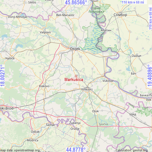
Markušica GPS coordinates[2]
45° 22' 26.004" North, 18° 42' 20.988" East
| Map corner | latitude | longitude |
|---|---|---|
| Upper-left | 45.86566°, | 18.00271° |
| Center: | 45.37389°, | 18.70583° |
| Lower-right: | 44.8778°, | 19.40896° |
| Map W x H: | 109.8×109.8 km | = 68.2×68.2mi |
| max Lat: | 46.52694° ⇑53.4% North |
| Markušica: | 45.37389° |
| min Lat: | ⇓46.6% South 42.54972° |
| min Long | Markušica | max Long |
| 13.52389° | 18.70583° | 19.37694° |
| W 94.2%⇐ | ⇒5.8% E |
Elevation
Elevation of Markušica is 88 m = 289 ft, and this is 65.3 m = 214 ft below average elevation for this country.
| Max E: |
827 m = 2713 ft | 76.5% |
| Avg. | 153.3 m = 503 ft | |
| Markušica | 88 m = 289 ft | |
Min E: |
-1 m = -3 ft | 23.5% |
See also: Croatia elevation on elevation.city.
Geographical zone
Markušica is located in North temperate zone (between Tropic of Cancer and the Arctic Circle). Distance of this North polar circle is 2356.1 km =1464 mi to North.| Distance of | km | miles | from Markušica |
|---|---|---|---|
| North Pole | 4962 | 3083.2 | to North |
| Arctic Circle | 2356.1 | 1464 | to North |
| Tropic Cancer | 2439.2 | 1515.6 | to South |
| Equator | 5045.1 | 3134.9 | to South |


Nearby cities:
15 places around Markušica: (largest is in red/bold)
• Antin
3.6 km =2.2 mi,  76°
76°
• Ernestinovo
9.4 km =5.8 mi,  337°
337°
• Gaboš
3.3 km =2.1 mi,  134°
134°
• Ivankovo
9.6 km =6 mi,  190°
190°
• Jarmina
6.5 km =4 mi,  163°
163°
• Kešinci
11.8 km =7.3 mi,  257°
257°
• Koritna
11 km =6.8 mi,  276°
276°
• Laslovo
4.6 km =2.9 mi,  350°
350°
• Mrzović
10.3 km =6.4 mi,  239°
239°
• Nuštar
11.5 km =7.1 mi,  113°
113°
• Ostrovo
7.5 km =4.7 mi,  119°
119°
• Pačetin
11.1 km =6.9 mi,  90°
90°
• Tordinci
7 km =4.3 mi, 93°
• Vinkovci
12.3 km =7.6 mi,  140°
140°
• Šodolovci
7.3 km =4.5 mi,  293°
293°
Sources, notices
• [Note1] Compared only with cities in Croatia existing in our database
• [Src1] Map data: © OpenStreetMap contributors (CC-BY-SA)
• [Src2] Other city data from geonames.org with taken over terms of usage.
• [Src3] Geographical zone / Annual Mean Temperature by Robert A. Rohde @ Wikipedia
