Ljupina geodata
Ljupina (Slavonski Brod-Posavina) is a populated place; located in Croatia in Europe/Zagreb (GMT+2) time zone. With population of 987 people, there are 461 cities with bigger population in this country. Compared to other cities in Croatia, 66.2% of cities are located further ↑North; 74.1% of cities are located further ←West and 66.9% of cities have higher elevation than Ljupina. Note1


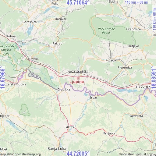
Ljupina GPS coordinates[2]
45° 13' 3" North, 17° 22' 58.008" East
| Map corner | latitude | longitude |
|---|---|---|
| Upper-left | 45.71064°, | 16.67966° |
| Center: | 45.2175°, | 17.38278° |
| Lower-right: | 44.72005°, | 18.08591° |
| Map W x H: | 110.1×110.1 km | = 68.4×68.4mi |
| max Lat: | 46.52694° ⇑66.2% North |
| Ljupina: | 45.2175° |
| min Lat: | ⇓33.8% South 42.54972° |
| min Long | Ljupina | max Long |
| 13.52389° | 17.38278° | 19.37694° |
| W 74.1%⇐ | ⇒25.9% E |
Elevation
Elevation of Ljupina is 100 m = 328 ft, and this is 53.3 m = 175 ft below average elevation for this country.
| Max E: |
827 m = 2713 ft | 66.9% |
| Avg. | 153.3 m = 503 ft | |
| Ljupina | 100 m = 328 ft | |
Min E: |
-1 m = -3 ft | 33.1% |
See also: Croatia elevation on elevation.city.
Geographical zone
Ljupina is located in North temperate zone (between Tropic of Cancer and the Arctic Circle). Distance of this North polar circle is 2373.5 km =1474.8 mi to North.| Distance of | km | miles | from Ljupina |
|---|---|---|---|
| North Pole | 4979.3 | 3094 | to North |
| Arctic Circle | 2373.5 | 1474.8 | to North |
| Tropic Cancer | 2421.8 | 1504.8 | to South |
| Equator | 5027.7 | 3124.1 | to South |


Nearby cities:
15 places around Ljupina: (largest is in red/bold)
• Adžamovci
7.3 km =4.5 mi,  62°
62°
• Bodovaljci
5.2 km =3.2 mi,  114°
114°
• Cernik
7.9 km =4.9 mi,  359°
359°
• Dragalić
7.9 km =4.9 mi,  291°
291°
• Godinjak
9.1 km =5.7 mi,  76°
76°
• Gornji Bogičevci
12.4 km =7.7 mi, 292°
• Kovačevac
5.6 km =3.5 mi,  347°
347°
• Nova Gradiška
4.2 km =2.6 mi,  0°
0°
• Orubica
9.8 km =6.1 mi,  142°
142°
• Prvča
3.4 km =2.1 mi,  327°
327°
• Rešetari
5.9 km =3.7 mi,  32°
32°
• Stara Gradiška
13.1 km =8.1 mi,  234°
234°
• Staro Petrovo Selo
10.9 km =6.8 mi, 82°
• Vrbje
4.4 km =2.7 mi, 139°
• Štivica
12.9 km =8 mi, 106°
Sources, notices
• [Note1] Compared only with cities in Croatia existing in our database
• [Src1] Map data: © OpenStreetMap contributors (CC-BY-SA)
• [Src2] Other city data from geonames.org with taken over terms of usage.
• [Src3] Geographical zone / Annual Mean Temperature by Robert A. Rohde @ Wikipedia
