Stara Gradiška geodata
Stara Gradiška (Slavonski Brod-Posavina) is a seat of a second-order administrative division; located in Croatia in Europe/Zagreb (GMT+2) time zone. In our database, there are 904 cities with bigger population. Compared to other cities in Croatia, 71.3% of cities are located further ↑North; 72.8% of cities are located further ←West and 73.8% of cities have higher elevation than Stara Gradiška. Note1


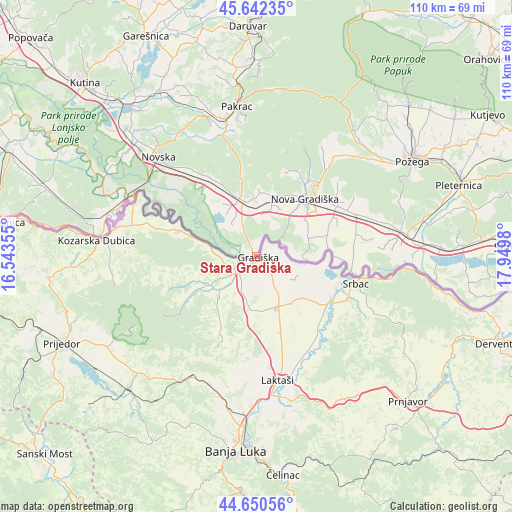
Stara Gradiška GPS coordinates[2]
45° 8' 54.996" North, 17° 14' 48.012" East
| Map corner | latitude | longitude |
|---|---|---|
| Upper-left | 45.64235°, | 16.54355° |
| Center: | 45.14861°, | 17.24667° |
| Lower-right: | 44.65056°, | 17.9498° |
| Map W x H: | 110.3×110.3 km | = 68.5×68.5mi |
| max Lat: | 46.52694° ⇑71.3% North |
| Stara Gradiška: | 45.14861° |
| min Lat: | ⇓28.7% South 42.54972° |
| min Long | Stara Gradiška | max Long |
| 13.52389° | 17.24667° | 19.37694° |
| W 72.8%⇐ | ⇒27.2% E |
Elevation
Elevation of Stara Gradiška is 90 m = 295 ft, and this is 63.3 m = 208 ft below average elevation for this country.
| Max E: |
827 m = 2713 ft | 73.8% |
| Avg. | 153.3 m = 503 ft | |
| Stara Gradiška | 90 m = 295 ft | |
Min E: |
-1 m = -3 ft | 26.2% |
See also: Croatia elevation on elevation.city.
Geographical zone
Stara Gradiška is located in North temperate zone (between Tropic of Cancer and the Arctic Circle). Distance of this North polar circle is 2381.1 km =1479.5 mi to North.| Distance of | km | miles | from Stara Gradiška |
|---|---|---|---|
| North Pole | 4987 | 3098.8 | to North |
| Arctic Circle | 2381.1 | 1479.5 | to North |
| Tropic Cancer | 2414.1 | 1500.1 | to South |
| Equator | 5020.1 | 3119.3 | to South |


Nearby cities:
15 places around Stara Gradiška: (largest is in red/bold)
• Adžamovci
20.4 km =12.7 mi,  57°
57°
• Bodovaljci
16.4 km =10.2 mi,  70°
70°
• Cernik
18.8 km =11.7 mi,  34°
34°
• Davor
21.5 km =13.4 mi,  99°
99°
• Dragalić
11.1 km =6.9 mi,  17°
17°
• Godinjak
21.9 km =13.6 mi, 63°
• Gornji Bogičevci
12.4 km =7.7 mi,  356°
356°
• Kovačevac
16.1 km =10 mi,  35°
35°
• Ljupina
13.1 km =8.1 mi,  54°
54°
• Nova Gradiška
15.9 km =9.9 mi, 42°
• Okučani
13 km =8.1 mi,  343°
343°
• Orubica
16.6 km =10.3 mi,  90°
90°
• Prvča
13.8 km =8.6 mi, 39°
• Rešetari
18.8 km =11.7 mi, 47°
• Vrbje
14.2 km =8.8 mi, 72°
Sources, notices
• [Note1] Compared only with cities in Croatia existing in our database
• [Src1] Map data: © OpenStreetMap contributors (CC-BY-SA)
• [Src2] Other city data from geonames.org with taken over terms of usage.
• [Src3] Geographical zone / Annual Mean Temperature by Robert A. Rohde @ Wikipedia
