Kravarsko geodata
Kravarsko (Zagrebačka) is a seat of a second-order administrative division; located in Croatia in Europe/Zagreb (GMT+2) time zone. In our database, there are 904 cities with bigger population. Compared to other cities in Croatia, 57.8% of cities are located further ↓South; 67.6% of cities are located further →East and 80.5% of cities have lower elevation than Kravarsko. Note1


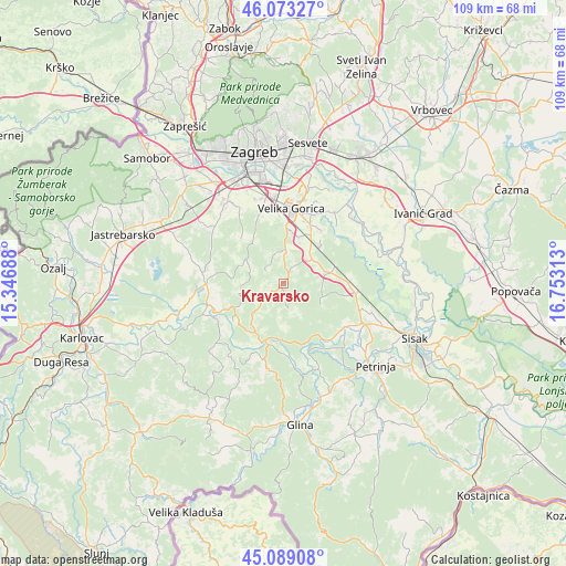
Kravarsko GPS coordinates[2]
45° 34' 59.988" North, 16° 3' 0" East
| Map corner | latitude | longitude |
|---|---|---|
| Upper-left | 46.07327°, | 15.34688° |
| Center: | 45.58333°, | 16.05° |
| Lower-right: | 45.08908°, | 16.75313° |
| Map W x H: | 109.4×109.4 km | = 68×68mi |
| max Lat: | 46.52694° ⇑42.2% North |
| Kravarsko: | 45.58333° |
| min Lat: | ⇓57.8% South 42.54972° |
| min Long | Kravarsko | max Long |
| 13.52389° | 16.05° | 19.37694° |
| W 32.4%⇐ | ⇒67.6% E |
Elevation
Elevation of Kravarsko is 206 m = 676 ft, and this is 52.7 m = 173 ft above average elevation for this country.
| Max E: |
827 m = 2713 ft | 19.5% |
| Kravarsko | 206 m 676 ft | |
| Avg. | 153.3 m = 503 ft | |
Min E: |
-1 m = -3 ft | 80.5% |
See also: Croatia elevation on elevation.city.
Geographical zone
Kravarsko is located in North temperate zone (between Tropic of Cancer and the Arctic Circle). Distance of this North polar circle is 2332.8 km =1449.5 mi to North.| Distance of | km | miles | from Kravarsko |
|---|---|---|---|
| North Pole | 4938.7 | 3068.8 | to North |
| Arctic Circle | 2332.8 | 1449.5 | to North |
| Tropic Cancer | 2462.5 | 1530.1 | to South |
| Equator | 5068.4 | 3149.4 | to South |


Nearby cities:
15 places around Kravarsko: (largest is in red/bold)
• Buševec
7.9 km =4.9 mi,  43°
43°
• Gradići
13 km =8.1 mi,  0°
0°
• Kuče
12.8 km =8 mi, 35°
• Lekenik
12.6 km =7.8 mi,  88°
88°
• Lukavec
14.3 km =8.9 mi,  340°
340°
• Mraclin
9.9 km =6.2 mi,  20°
20°
• Novo Čiče
14 km =8.7 mi, 21°
• Petrovina Turopoljska
13 km =8.1 mi,  354°
354°
• Pokupsko
11.6 km =7.2 mi,  202°
202°
• Rakitovec
12.1 km =7.5 mi, 40°
• Staro Čiče
14 km =8.7 mi, 21°
• Turopolje
10.3 km =6.4 mi, 44°
• Velika Buna
5.7 km =3.5 mi,  13°
13°
• Vukovina
12.3 km =7.6 mi, 24°
• Šiljakovina
6.1 km =3.8 mi,  334°
334°
Sources, notices
• [Note1] Compared only with cities in Croatia existing in our database
• [Src1] Map data: © OpenStreetMap contributors (CC-BY-SA)
• [Src2] Other city data from geonames.org with taken over terms of usage.
• [Src3] Geographical zone / Annual Mean Temperature by Robert A. Rohde @ Wikipedia
