Klanjec geodata
Klanjec (Krapinsko-Zagorska) is a seat of a second-order administrative division; located in Croatia in Europe/Zagreb (GMT+2) time zone. With population of 565 people, there are 793 cities with bigger population in this country. Compared to other cities in Croatia, 83.3% of cities are located further ↓South; 77.6% of cities are located further →East and 87% of cities have lower elevation than Klanjec. Note1


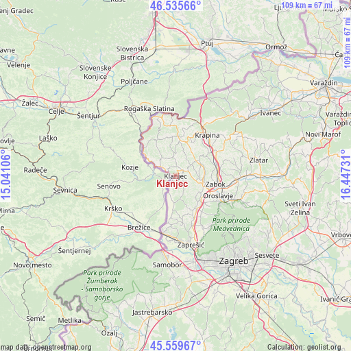
Klanjec GPS coordinates[2]
46° 2' 59.352" North, 15° 44' 39.048" East
| Map corner | latitude | longitude |
|---|---|---|
| Upper-left | 46.53566°, | 15.04106° |
| Center: | 46.04982°, | 15.74418° |
| Lower-right: | 45.55967°, | 16.44731° |
| Map W x H: | 108.5×108.5 km | = 67.4×67.4mi |
| max Lat: | 46.52694° ⇑16.7% North |
| Klanjec: | 46.04982° |
| min Lat: | ⇓83.3% South 42.54972° |
| min Long | Klanjec | max Long |
| 13.52389° | 15.74418° | 19.37694° |
| W 22.4%⇐ | ⇒77.6% E |
Elevation
Elevation of Klanjec is 258 m = 846 ft, and this is 104.7 m = 344 ft above average elevation for this country.
| Max E: |
827 m = 2713 ft | 13% |
| Klanjec | 258 m 846 ft | |
| Avg. | 153.3 m = 503 ft | |
Min E: |
-1 m = -3 ft | 87% |
See also: Croatia elevation on elevation.city.
Geographical zone
Klanjec is located in North temperate zone (between Tropic of Cancer and the Arctic Circle). Distance of this North polar circle is 2280.9 km =1417.3 mi to North.| Distance of | km | miles | from Klanjec |
|---|---|---|---|
| North Pole | 4886.8 | 3036.5 | to North |
| Arctic Circle | 2280.9 | 1417.3 | to North |
| Tropic Cancer | 2514.3 | 1562.3 | to South |
| Equator | 5120.3 | 3181.6 | to South |


Nearby cities:
15 places around Klanjec: (largest is in red/bold)
• Desinić
12.4 km =7.7 mi,  332°
332°
• Donja Pačetina
11.6 km =7.2 mi,  66°
66°
• Dubravica
11.1 km =6.9 mi,  184°
184°
• Dubrovčan
4.3 km =2.7 mi,  86°
86°
• Kraljevec na Sutli
6.7 km =4.2 mi,  192°
192°
• Krapinske Toplice
9 km =5.6 mi,  57°
57°
• Kumrovec
6.1 km =3.8 mi,  300°
300°
• Luka
11.8 km =7.3 mi,  150°
150°
• Mala Erpenja
6 km =3.7 mi,  31°
31°
• Pregrada
12.7 km =7.9 mi,  2°
2°
• Radakovo
6.9 km =4.3 mi,  163°
163°
• Tuhelj
3 km =1.9 mi, 4°
• Veliko Trgovišće
9.9 km =6.2 mi,  124°
124°
• Zagorska Sela
9.9 km =6.2 mi, 301°
• Škarićevo
11.7 km =7.3 mi,  44°
44°
Sources, notices
• [Note1] Compared only with cities in Croatia existing in our database
• [Src1] Map data: © OpenStreetMap contributors (CC-BY-SA)
• [Src2] Other city data from geonames.org with taken over terms of usage.
• [Src3] Geographical zone / Annual Mean Temperature by Robert A. Rohde @ Wikipedia
