Luka geodata
Luka (Zagrebačka) is a seat of a second-order administrative division; located in Croatia in Europe/Zagreb (GMT+2) time zone. With population of 880 people, there are 540 cities with bigger population in this country. Compared to other cities in Croatia, 80.1% of cities are located further ↓South; 74.6% of cities are located further →East and 56.9% of cities have lower elevation than Luka. Note1


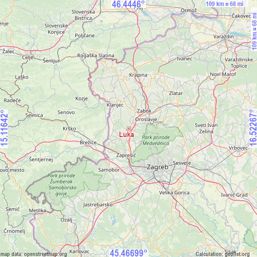
Luka GPS coordinates[2]
45° 57' 28.62" North, 15° 49' 10.344" East
| Map corner | latitude | longitude |
|---|---|---|
| Upper-left | 46.4446°, | 15.11642° |
| Center: | 45.95795°, | 15.81954° |
| Lower-right: | 45.46699°, | 16.52267° |
| Map W x H: | 108.7×108.7 km | = 67.5×67.5mi |
| max Lat: | 46.52694° ⇑19.9% North |
| Luka: | 45.95795° |
| min Lat: | ⇓80.1% South 42.54972° |
| min Long | Luka | max Long |
| 13.52389° | 15.81954° | 19.37694° |
| W 25.4%⇐ | ⇒74.6% E |
Elevation
Elevation of Luka is 139 m = 456 ft, and this is 14.3 m = 47 ft below average elevation for this country.
| Max E: |
827 m = 2713 ft | 43.1% |
| Avg. | 153.3 m = 503 ft | |
| Luka | 139 m = 456 ft | |
Min E: |
-1 m = -3 ft | 56.9% |
See also: Croatia elevation on elevation.city.
Geographical zone
Luka is located in North temperate zone (between Tropic of Cancer and the Arctic Circle). Distance of this North polar circle is 2291.1 km =1423.6 mi to North.| Distance of | km | miles | from Luka |
|---|---|---|---|
| North Pole | 4897 | 3042.9 | to North |
| Arctic Circle | 2291.1 | 1423.6 | to North |
| Tropic Cancer | 2504.1 | 1556 | to South |
| Equator | 5110 | 3175.2 | to South |


Nearby cities:
15 places around Luka: (largest is in red/bold)
• Donja Bistra
6.2 km =3.9 mi,  154°
154°
• Donja Pušća
5.6 km =3.5 mi,  215°
215°
• Dubravica
6.7 km =4.2 mi,  262°
262°
• Gornja Bistra
7.7 km =4.8 mi,  126°
126°
• Gornja Pušća
4.9 km =3 mi,  228°
228°
• Igrišće
4.5 km =2.8 mi,  84°
84°
• Jakovlje
3.7 km =2.3 mi, 131°
• Kraljevec na Sutli
8.2 km =5.1 mi,  296°
296°
• Kupljenovo
3.4 km =2.1 mi,  198°
198°
• Oroslavje
8.5 km =5.3 mi,  59°
59°
• Pojatno
6.1 km =3.8 mi,  193°
193°
• Poljanica Bistranska
7.7 km =4.8 mi, 145°
• Radakovo
5.3 km =3.3 mi,  313°
313°
• Stubička Slatina
4.6 km =2.9 mi, 63°
• Veliko Trgovišće
5.2 km =3.2 mi,  26°
26°
Sources, notices
• [Note1] Compared only with cities in Croatia existing in our database
• [Src1] Map data: © OpenStreetMap contributors (CC-BY-SA)
• [Src2] Other city data from geonames.org with taken over terms of usage.
• [Src3] Geographical zone / Annual Mean Temperature by Robert A. Rohde @ Wikipedia
