Dubravica geodata
Dubravica (Zagrebačka) is a seat of a second-order administrative division; located in Croatia in Europe/Zagreb (GMT+2) time zone. In our database, there are 904 cities with bigger population. Compared to other cities in Croatia, 79.9% of cities are located further ↓South; 78.2% of cities are located further →East and 65.7% of cities have lower elevation than Dubravica. Note1


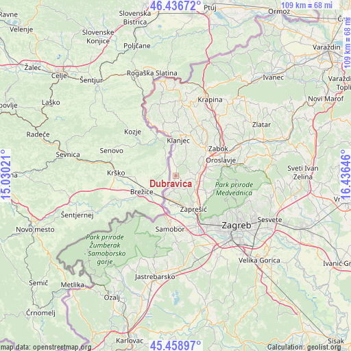
Dubravica GPS coordinates[2]
45° 57' 0" North, 15° 43' 59.988" East
| Map corner | latitude | longitude |
|---|---|---|
| Upper-left | 46.43672°, | 15.03021° |
| Center: | 45.95°, | 15.73333° |
| Lower-right: | 45.45897°, | 16.43646° |
| Map W x H: | 108.7×108.7 km | = 67.5×67.5mi |
| max Lat: | 46.52694° ⇑20.1% North |
| Dubravica: | 45.95° |
| min Lat: | ⇓79.9% South 42.54972° |
| min Long | Dubravica | max Long |
| 13.52389° | 15.73333° | 19.37694° |
| W 21.8%⇐ | ⇒78.2% E |
Elevation
Elevation of Dubravica is 156 m = 512 ft, and this is 2.7 m = 9 ft above average elevation for this country.
| Max E: |
827 m = 2713 ft | 34.3% |
| Dubravica | 156 m 512 ft | |
| Avg. | 153.3 m = 503 ft | |
Min E: |
-1 m = -3 ft | 65.7% |
See also: Croatia elevation on elevation.city.
Geographical zone
Dubravica is located in North temperate zone (between Tropic of Cancer and the Arctic Circle). Distance of this North polar circle is 2292 km =1424.2 mi to North.| Distance of | km | miles | from Dubravica |
|---|---|---|---|
| North Pole | 4897.9 | 3043.4 | to North |
| Arctic Circle | 2292 | 1424.2 | to North |
| Tropic Cancer | 2503.2 | 1555.4 | to South |
| Equator | 5109.2 | 3174.7 | to South |


Nearby cities:
15 places around Dubravica: (largest is in red/bold)
• Brdovec
9.7 km =6 mi,  162°
162°
• Donja Pušća
5.1 km =3.2 mi,  137°
137°
• Donji Laduč
7.4 km =4.6 mi,  180°
180°
• Gornja Pušća
3.8 km =2.4 mi,  128°
128°
• Gornji Laduč
7.5 km =4.7 mi,  192°
192°
• Jakovlje
9.6 km =6 mi,  99°
99°
• Ključ Brdovečki
8.1 km =5 mi,  202°
202°
• Kraljevec na Sutli
4.6 km =2.9 mi,  351°
351°
• Kupljenovo
6.1 km =3.8 mi,  112°
112°
• Luka
6.7 km =4.2 mi,  82°
82°
• Marija Gorica
4.4 km =2.7 mi, 185°
• Pojatno
7.2 km =4.5 mi, 133°
• Prigorje Brdovečko
7.9 km =4.9 mi, 177°
• Radakovo
5.3 km =3.3 mi,  32°
32°
• Zdenci Brdovečki
9.4 km =5.8 mi,  172°
172°
Sources, notices
• [Note1] Compared only with cities in Croatia existing in our database
• [Src1] Map data: © OpenStreetMap contributors (CC-BY-SA)
• [Src2] Other city data from geonames.org with taken over terms of usage.
• [Src3] Geographical zone / Annual Mean Temperature by Robert A. Rohde @ Wikipedia
