Jadranovo geodata
Jadranovo (Primorsko-Goranska) is a populated place; located in Croatia in Europe/Zagreb (GMT+2) time zone. With population of 1,224 people, there are 368 cities with bigger population in this country. Compared to other cities in Croatia, 64.4% of cities are located further ↑North; 91.4% of cities are located further →East and 85.6% of cities have higher elevation than Jadranovo. Note1


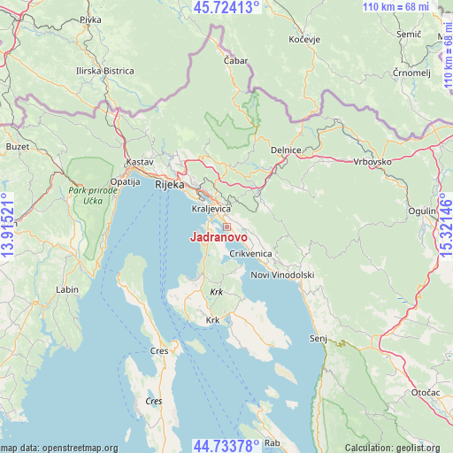
Jadranovo GPS coordinates[2]
45° 13' 51.996" North, 14° 37' 5.988" East
| Map corner | latitude | longitude |
|---|---|---|
| Upper-left | 45.72413°, | 13.91521° |
| Center: | 45.23111°, | 14.61833° |
| Lower-right: | 44.73378°, | 15.32146° |
| Map W x H: | 110.1×110.1 km | = 68.4×68.4mi |
| max Lat: | 46.52694° ⇑64.4% North |
| Jadranovo: | 45.23111° |
| min Lat: | ⇓35.6% South 42.54972° |
| min Long | Jadranovo | max Long |
| 13.52389° | 14.61833° | 19.37694° |
| W 8.6%⇐ | ⇒91.4% E |
Elevation
Elevation of Jadranovo is 59 m = 194 ft, and this is 94.3 m = 309 ft below average elevation for this country.
| Max E: |
827 m = 2713 ft | 85.6% |
| Avg. | 153.3 m = 503 ft | |
| Jadranovo | 59 m = 194 ft | |
Min E: |
-1 m = -3 ft | 14.4% |
See also: Croatia elevation on elevation.city.
Geographical zone
Jadranovo is located in North temperate zone (between Tropic of Cancer and the Arctic Circle). Distance of this North polar circle is 2371.9 km =1473.8 mi to North.| Distance of | km | miles | from Jadranovo |
|---|---|---|---|
| North Pole | 4977.8 | 3093.1 | to North |
| Arctic Circle | 2371.9 | 1473.8 | to North |
| Tropic Cancer | 2423.3 | 1505.8 | to South |
| Equator | 5029.2 | 3125 | to South |


Nearby cities:
15 places around Jadranovo: (largest is in red/bold)
• Bakar
11 km =6.8 mi,  321°
321°
• Crikvenica
8.4 km =5.2 mi,  135°
135°
• Dobrinj
11.7 km =7.3 mi,  185°
185°
• Fužine
11.2 km =7 mi,  42°
42°
• Hreljin
5.9 km =3.7 mi,  345°
345°
• Kostrena
11.8 km =7.3 mi,  311°
311°
• Kraljevica
6.2 km =3.9 mi, 320°
• Krasica
10 km =6.2 mi,  330°
330°
• Lič
9.5 km =5.9 mi,  55°
55°
• Njivice
10.2 km =6.3 mi,  217°
217°
• Omišalj
5.4 km =3.4 mi,  246°
246°
• Praputnjak
8.3 km =5.2 mi,  335°
335°
• Selce
11.6 km =7.2 mi, 135°
• Tribalj
4.8 km =3 mi,  102°
102°
• Šmrika
2.4 km =1.5 mi, 327°
Sources, notices
• [Note1] Compared only with cities in Croatia existing in our database
• [Src1] Map data: © OpenStreetMap contributors (CC-BY-SA)
• [Src2] Other city data from geonames.org with taken over terms of usage.
• [Src3] Geographical zone / Annual Mean Temperature by Robert A. Rohde @ Wikipedia
