Hrastovsko geodata
Hrastovsko (Varaždinska) is a populated place; located in Croatia in Europe/Zagreb (GMT+2) time zone. With population of 760 people, there are 622 cities with bigger population in this country. Compared to other cities in Croatia, 90.3% of cities are located further ↓South; 55.4% of cities are located further ←West and 65.7% of cities have lower elevation than Hrastovsko. Note1


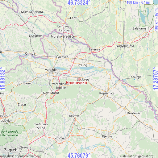
Hrastovsko GPS coordinates[2]
46° 14' 57.012" North, 16° 35' 3.984" East
| Map corner | latitude | longitude |
|---|---|---|
| Upper-left | 46.73324°, | 15.88132° |
| Center: | 46.24917°, | 16.58444° |
| Lower-right: | 45.76079°, | 17.28757° |
| Map W x H: | 108.1×108.1 km | = 67.2×67.2mi |
| max Lat: | 46.52694° ⇑9.7% North |
| Hrastovsko: | 46.24917° |
| min Lat: | ⇓90.3% South 42.54972° |
| min Long | Hrastovsko | max Long |
| 13.52389° | 16.58444° | 19.37694° |
| W 55.4%⇐ | ⇒44.6% E |
Elevation
Elevation of Hrastovsko is 156 m = 512 ft, and this is 2.7 m = 9 ft above average elevation for this country.
| Max E: |
827 m = 2713 ft | 34.3% |
| Hrastovsko | 156 m 512 ft | |
| Avg. | 153.3 m = 503 ft | |
Min E: |
-1 m = -3 ft | 65.7% |
See also: Croatia elevation on elevation.city.
Geographical zone
Hrastovsko is located in North temperate zone (between Tropic of Cancer and the Arctic Circle). Distance of this North polar circle is 2258.7 km =1403.5 mi to North.| Distance of | km | miles | from Hrastovsko |
|---|---|---|---|
| North Pole | 4864.6 | 3022.7 | to North |
| Arctic Circle | 2258.7 | 1403.5 | to North |
| Tropic Cancer | 2536.5 | 1576.1 | to South |
| Equator | 5142.4 | 3195.3 | to South |


Nearby cities:
15 places around Hrastovsko: (largest is in red/bold)
• Hrženica
5.6 km =3.5 mi,  352°
352°
• Jalžabet
8.5 km =5.3 mi,  278°
278°
• Karlovec Ludbreški
5.9 km =3.7 mi,  36°
36°
• Ludbreg
2.3 km =1.4 mi,  82°
82°
• Martijanec
3.9 km =2.4 mi,  298°
298°
• Podbrest
9.6 km =6 mi,  341°
341°
• Poljanec
2.1 km =1.3 mi, 336°
• Prelog
9.8 km =6.1 mi,  14°
14°
• Selnik
2.9 km =1.8 mi, 43°
• Sigetec Ludbreški
4.3 km =2.7 mi,  74°
74°
• Slanje
3.7 km =2.3 mi,  237°
237°
• Sveti Ðurđ
4.2 km =2.6 mi,  21°
21°
• Vinogradi Ludbreški
1.8 km =1.1 mi,  182°
182°
• Vrbanovec
5.3 km =3.3 mi,  289°
289°
• Šemovec
10.7 km =6.6 mi, 304°
Sources, notices
• [Note1] Compared only with cities in Croatia existing in our database
• [Src1] Map data: © OpenStreetMap contributors (CC-BY-SA)
• [Src2] Other city data from geonames.org with taken over terms of usage.
• [Src3] Geographical zone / Annual Mean Temperature by Robert A. Rohde @ Wikipedia
