Jalžabet geodata
Jalžabet (Varaždinska) is a seat of a second-order administrative division; located in Croatia in Europe/Zagreb (GMT+2) time zone. With population of 1,070 people, there are 423 cities with bigger population in this country. Compared to other cities in Croatia, 91.2% of cities are located further ↓South; 50.8% of cities are located further ←West and 71.3% of cities have lower elevation than Jalžabet. Note1


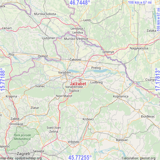
Jalžabet GPS coordinates[2]
46° 15' 38.988" North, 16° 28' 30" East
| Map corner | latitude | longitude |
|---|---|---|
| Upper-left | 46.7448°, | 15.77188° |
| Center: | 46.26083°, | 16.475° |
| Lower-right: | 45.77255°, | 17.17813° |
| Map W x H: | 108.1×108.1 km | = 67.2×67.2mi |
| max Lat: | 46.52694° ⇑8.8% North |
| Jalžabet: | 46.26083° |
| min Lat: | ⇓91.2% South 42.54972° |
| min Long | Jalžabet | max Long |
| 13.52389° | 16.475° | 19.37694° |
| W 50.8%⇐ | ⇒49.2% E |
Elevation
Elevation of Jalžabet is 170 m = 558 ft, and this is 16.7 m = 55 ft above average elevation for this country.
| Max E: |
827 m = 2713 ft | 28.7% |
| Jalžabet | 170 m 558 ft | |
| Avg. | 153.3 m = 503 ft | |
Min E: |
-1 m = -3 ft | 71.3% |
See also: Croatia elevation on elevation.city.
Geographical zone
Jalžabet is located in North temperate zone (between Tropic of Cancer and the Arctic Circle). Distance of this North polar circle is 2257.5 km =1402.7 mi to North.| Distance of | km | miles | from Jalžabet |
|---|---|---|---|
| North Pole | 4863.3 | 3021.9 | to North |
| Arctic Circle | 2257.5 | 1402.7 | to North |
| Tropic Cancer | 2537.8 | 1576.9 | to South |
| Equator | 5143.7 | 3196.1 | to South |


Nearby cities:
15 places around Jalžabet: (largest is in red/bold)
• Bartolovec
4.9 km =3 mi,  327°
327°
• Donji Kneginec
7 km =4.3 mi,  268°
268°
• Donji Kućan
6.6 km =4.1 mi,  289°
289°
• Gornji Kneginec
7.7 km =4.8 mi,  261°
261°
• Kelemen
3.1 km =1.9 mi, 261°
• Martijanec
5 km =3.1 mi,  83°
83°
• Orehovica
8.3 km =5.2 mi,  17°
17°
• Poljanec
7.6 km =4.7 mi,  85°
85°
• Slanje
6.2 km =3.9 mi,  121°
121°
• Trnovec Bartolovečki
7 km =4.3 mi,  302°
302°
• Tuhovec
7 km =4.3 mi,  195°
195°
• Varaždinske Toplice
7.2 km =4.5 mi,  216°
216°
• Vrbanovec
3.5 km =2.2 mi, 82°
• Zbelava
5.7 km =3.5 mi, 297°
• Šemovec
4.8 km =3 mi,  355°
355°
Sources, notices
• [Note1] Compared only with cities in Croatia existing in our database
• [Src1] Map data: © OpenStreetMap contributors (CC-BY-SA)
• [Src2] Other city data from geonames.org with taken over terms of usage.
• [Src3] Geographical zone / Annual Mean Temperature by Robert A. Rohde @ Wikipedia
