Gornja Voća geodata
Gornja Voća (Varaždinska) is a populated place; located in Croatia in Europe/Zagreb (GMT+2) time zone. With population of 571 people, there are 782 cities with bigger population in this country. Compared to other cities in Croatia, 94% of cities are located further ↓South; 66.4% of cities are located further →East and 85.1% of cities have lower elevation than Gornja Voća. Note1


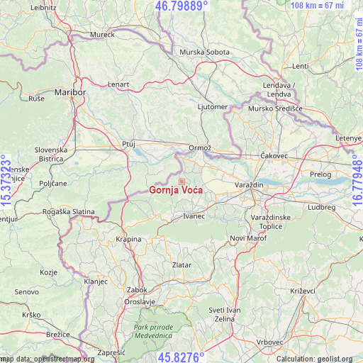
Gornja Voća GPS coordinates[2]
46° 18' 55.44" North, 16° 4' 34.86" East
| Map corner | latitude | longitude |
|---|---|---|
| Upper-left | 46.79889°, | 15.37323° |
| Center: | 46.3154°, | 16.07635° |
| Lower-right: | 45.8276°, | 16.77948° |
| Map W x H: | 108×108 km | = 67.1×67.1mi |
| max Lat: | 46.52694° ⇑6% North |
| Gornja Voća: | 46.3154° |
| min Lat: | ⇓94% South 42.54972° |
| min Long | Gornja Voća | max Long |
| 13.52389° | 16.07635° | 19.37694° |
| W 33.6%⇐ | ⇒66.4% E |
Elevation
Elevation of Gornja Voća is 238 m = 781 ft, and this is 84.7 m = 278 ft above average elevation for this country.
| Max E: |
827 m = 2713 ft | 14.9% |
| Gornja Voća | 238 m 781 ft | |
| Avg. | 153.3 m = 503 ft | |
Min E: |
-1 m = -3 ft | 85.1% |
See also: Croatia elevation on elevation.city.
Geographical zone
Gornja Voća is located in North temperate zone (between Tropic of Cancer and the Arctic Circle). Distance of this North polar circle is 2251.4 km =1399 mi to North.| Distance of | km | miles | from Gornja Voća |
|---|---|---|---|
| North Pole | 4857.3 | 3018.2 | to North |
| Arctic Circle | 2251.4 | 1399 | to North |
| Tropic Cancer | 2543.9 | 1580.7 | to South |
| Equator | 5149.8 | 3199.9 | to South |


Nearby cities:
15 places around Gornja Voća: (largest is in red/bold)
• Bedenec
8.4 km =5.2 mi,  182°
182°
• Cestica
7.3 km =4.5 mi,  30°
30°
• Donja Višnjica
4.9 km =3 mi,  249°
249°
• Donja Voća
2.7 km =1.7 mi,  126°
126°
• Donje Ladanje
7.1 km =4.4 mi,  103°
103°
• Gornje Ladanje
7.1 km =4.4 mi,  93°
93°
• Gornje Vratno
7.7 km =4.8 mi,  50°
50°
• Ivanec
10.8 km =6.7 mi,  161°
161°
• Jerovec
8.9 km =5.5 mi, 163°
• Klenovnik
5 km =3.1 mi,  185°
185°
• Maruševec
8.7 km =5.4 mi,  109°
109°
• Marčan
5.7 km =3.5 mi,  74°
74°
• Vinica
6.1 km =3.8 mi, 67°
• Žarovnica
7.3 km =4.5 mi,  204°
204°
• Žarovnica
8.7 km =5.4 mi, 189°
Sources, notices
• [Note1] Compared only with cities in Croatia existing in our database
• [Src1] Map data: © OpenStreetMap contributors (CC-BY-SA)
• [Src2] Other city data from geonames.org with taken over terms of usage.
• [Src3] Geographical zone / Annual Mean Temperature by Robert A. Rohde @ Wikipedia
