Galovac geodata
Galovac (Zadarska) is a seat of a second-order administrative division; located in Croatia in Europe/Zagreb (GMT+2) time zone. With population of 1,196 people, there are 379 cities with bigger population in this country. Compared to other cities in Croatia, 82.9% of cities are located further ↑North; 84.3% of cities are located further →East and 84.7% of cities have higher elevation than Galovac. Note1


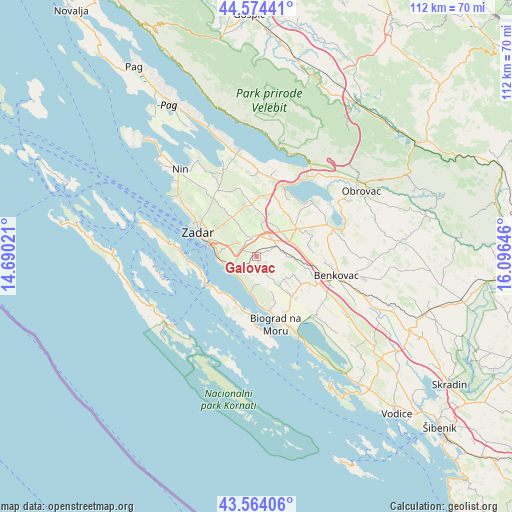
Galovac GPS coordinates[2]
44° 4' 17.004" North, 15° 23' 35.988" East
| Map corner | latitude | longitude |
|---|---|---|
| Upper-left | 44.57441°, | 14.69021° |
| Center: | 44.07139°, | 15.39333° |
| Lower-right: | 43.56406°, | 16.09646° |
| Map W x H: | 112.3×112.3 km | = 69.8×69.8mi |
| max Lat: | 46.52694° ⇑82.9% North |
| Galovac: | 44.07139° |
| min Lat: | ⇓17.1% South 42.54972° |
| min Long | Galovac | max Long |
| 13.52389° | 15.39333° | 19.37694° |
| W 15.7%⇐ | ⇒84.3% E |
Elevation
Elevation of Galovac is 70 m = 230 ft, and this is 83.3 m = 273 ft below average elevation for this country.
| Max E: |
827 m = 2713 ft | 84.7% |
| Avg. | 153.3 m = 503 ft | |
| Galovac | 70 m = 230 ft | |
Min E: |
-1 m = -3 ft | 15.3% |
See also: Croatia elevation on elevation.city.
Geographical zone
Galovac is located in North temperate zone (between Tropic of Cancer and the Arctic Circle). Distance of this Northern Tropic circle is 2294.4 km =1425.7 mi to South.| Distance of | km | miles | from Galovac |
|---|---|---|---|
| North Pole | 5106.8 | 3173.2 | to North |
| Arctic Circle | 2500.9 | 1554 | to North |
| Tropic Cancer | 2294.4 | 1425.7 | to South |
| Equator | 4900.3 | 3044.9 | to South |


Nearby cities:
15 places around Galovac: (largest is in red/bold)
• Bibinje
8.7 km =5.4 mi,  271°
271°
• Briševo
12.4 km =7.7 mi,  325°
325°
• Crno
9.4 km =5.8 mi,  300°
300°
• Debeljak
3.2 km =2 mi,  225°
225°
• Kukljica
12.5 km =7.8 mi,  250°
250°
• Murvica
10.1 km =6.3 mi, 326°
• Polača
11.5 km =7.1 mi,  120°
120°
• Poličnik
11.9 km =7.4 mi,  353°
353°
• Suhovare
9.6 km =6 mi,  6°
6°
• Sukošan
6.6 km =4.1 mi, 248°
• Sveti Filip i Jakov
12.2 km =7.6 mi,  166°
166°
• Tinj
8.7 km =5.4 mi,  131°
131°
• Turanj
11.2 km =7 mi, 172°
• Zemunik Donji
4.1 km =2.5 mi, 345°
• Škabrnje
5.3 km =3.3 mi,  65°
65°
Sources, notices
• [Note1] Compared only with cities in Croatia existing in our database
• [Src1] Map data: © OpenStreetMap contributors (CC-BY-SA)
• [Src2] Other city data from geonames.org with taken over terms of usage.
• [Src3] Geographical zone / Annual Mean Temperature by Robert A. Rohde @ Wikipedia
