Delnice geodata
Delnice (Primorsko-Goranska) is a seat of a second-order administrative division; located in Croatia in Europe/Zagreb (GMT+2) time zone. With population of 4,473 people, there are 88 cities with bigger population in this country. Compared to other cities in Croatia, 51.4% of cities are located further ↑North; 89.7% of cities are located further →East and 99.1% of cities have lower elevation than Delnice. Note1


Delnice GPS coordinates[2]
45° 24' 2.988" North, 14° 47' 58.992" East
| Map corner | latitude | longitude |
|---|---|---|
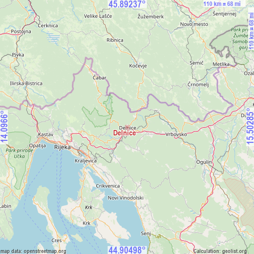
| Upper-left | 45.89237°, | 14.0966° |
| Center: | 45.40083°, | 14.79972° |
| Lower-right: | 44.90498°, | 15.50285° |
| Map W x H: | 109.8×109.8 km | = 68.2×68.2mi |
| max Lat: | 46.52694° ⇑51.4% North |
| Delnice: | 45.40083° |
| min Lat: | ⇓48.6% South 42.54972° |
| min Long | Delnice | max Long |
| 13.52389° | 14.79972° | 19.37694° |
| W 10.3%⇐ | ⇒89.7% E |
Elevation
Elevation of Delnice is 699 m = 2293 ft, and this is 545.7 m = 1790 ft above average elevation for this country.
| Max E: |
827 m = 2713 ft | 0.90000000000001% |
| Delnice | 699 m 2293 ft | |
| Avg. | 153.3 m = 503 ft | |
Min E: |
-1 m = -3 ft | 99.1% |
See also: Croatia elevation on elevation.city.
Geographical zone
Delnice is located in North temperate zone (between Tropic of Cancer and the Arctic Circle). Distance of this North polar circle is 2353.1 km =1462.1 mi to North.| Distance of | km | miles | from Delnice |
|---|---|---|---|
| North Pole | 4959 | 3081.4 | to North |
| Arctic Circle | 2353.1 | 1462.1 | to North |
| Tropic Cancer | 2442.2 | 1517.5 | to South |
| Equator | 5048.1 | 3136.7 | to South |


Nearby cities:
15 places around Delnice: (largest is in red/bold)
• Brod Moravice
15.4 km =9.6 mi,  62°
62°
• Fužine
12.5 km =7.8 mi,  211°
211°
• Gerovo
17.6 km =10.9 mi,  315°
315°
• Hreljin
20.5 km =12.7 mi,  229°
229°
• Krasica
21.6 km =13.4 mi,  242°
242°
• Kukuljanovo
21.9 km =13.6 mi,  247°
247°
• Lič
14.9 km =9.3 mi,  204°
204°
• Lokve
6.1 km =3.8 mi,  220°
220°
• Mrkopalj
10.4 km =6.5 mi,  155°
155°
• Praputnjak
21 km =13 mi, 237°
• Ravna Gora
11 km =6.8 mi,  106°
106°
• Skrad
9.2 km =5.7 mi,  70°
70°
• Tribalj
22.1 km =13.7 mi, 205°
• Vrbovsko
22.1 km =13.7 mi,  99°
99°
• Škrljevo
22.7 km =14.1 mi, 246°
Sources, notices
• [Note1] Compared only with cities in Croatia existing in our database
• [Src1] Map data: © OpenStreetMap contributors (CC-BY-SA)
• [Src2] Other city data from geonames.org with taken over terms of usage.
• [Src3] Geographical zone / Annual Mean Temperature by Robert A. Rohde @ Wikipedia
