Davor geodata
Davor (Slavonski Brod-Posavina) is a seat of a second-order administrative division; located in Croatia in Europe/Zagreb (GMT+2) time zone. With population of 2,525 people, there are 170 cities with bigger population in this country. Compared to other cities in Croatia, 72.7% of cities are located further ↑North; 76.2% of cities are located further ←West and 74.8% of cities have higher elevation than Davor. Note1


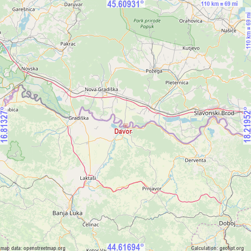
Davor GPS coordinates[2]
45° 6' 55.008" North, 17° 30' 59.004" East
| Map corner | latitude | longitude |
|---|---|---|
| Upper-left | 45.60931°, | 16.81327° |
| Center: | 45.11528°, | 17.51639° |
| Lower-right: | 44.61694°, | 18.21952° |
| Map W x H: | 110.3×110.3 km | = 68.5×68.5mi |
| max Lat: | 46.52694° ⇑72.7% North |
| Davor: | 45.11528° |
| min Lat: | ⇓27.3% South 42.54972° |
| min Long | Davor | max Long |
| 13.52389° | 17.51639° | 19.37694° |
| W 76.2%⇐ | ⇒23.8% E |
Elevation
Elevation of Davor is 89 m = 292 ft, and this is 64.3 m = 211 ft below average elevation for this country.
| Max E: |
827 m = 2713 ft | 74.8% |
| Avg. | 153.3 m = 503 ft | |
| Davor | 89 m = 292 ft | |
Min E: |
-1 m = -3 ft | 25.2% |
See also: Croatia elevation on elevation.city.
Geographical zone
Davor is located in North temperate zone (between Tropic of Cancer and the Arctic Circle). Distance of this North polar circle is 2384.8 km =1481.8 mi to North.| Distance of | km | miles | from Davor |
|---|---|---|---|
| North Pole | 4990.7 | 3101.1 | to North |
| Arctic Circle | 2384.8 | 1481.8 | to North |
| Tropic Cancer | 2410.4 | 1497.8 | to South |
| Equator | 5016.3 | 3117 | to South |


Nearby cities:
15 places around Davor: (largest is in red/bold)
• Adžamovci
15.3 km =9.5 mi,  344°
344°
• Batrina
14.4 km =8.9 mi,  54°
54°
• Bodovaljci
10.8 km =6.7 mi,  328°
328°
• Godinjak
13.6 km =8.5 mi,  353°
353°
• Ljupina
15.5 km =9.6 mi,  317°
317°
• Lužani
16.1 km =10 mi,  68°
68°
• Nova Gradiška
18.7 km =11.6 mi, 326°
• Nova Kapela
13.4 km =8.3 mi, 45°
• Orubica
5.8 km =3.6 mi,  308°
308°
• Prvča
18.9 km =11.7 mi, 319°
• Rešetari
17.9 km =11.1 mi, 335°
• Staro Petrovo Selo
12.9 km =8 mi,  1°
1°
• Vrbje
11.1 km =6.9 mi, 316°
• Vrbova
12.5 km =7.8 mi,  22°
22°
• Štivica
7.9 km =4.9 mi,  14°
14°
Sources, notices
• [Note1] Compared only with cities in Croatia existing in our database
• [Src1] Map data: © OpenStreetMap contributors (CC-BY-SA)
• [Src2] Other city data from geonames.org with taken over terms of usage.
• [Src3] Geographical zone / Annual Mean Temperature by Robert A. Rohde @ Wikipedia
