Babino Polje geodata
Babino Polje (Dubrovačko-Neretvanska) is a seat of a second-order administrative division; located in Croatia in Europe/Zagreb (GMT+2) time zone. In our database, there are 904 cities with bigger population. Compared to other cities in Croatia, 98.8% of cities are located further ↑North; 76.7% of cities are located further ←West and 66.9% of cities have lower elevation than Babino Polje. Note1


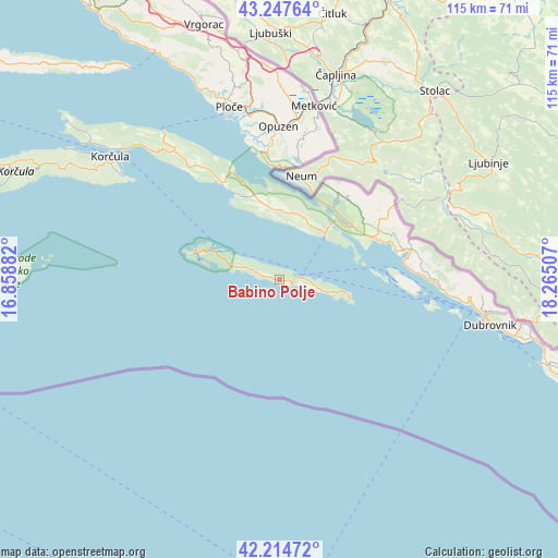
Babino Polje GPS coordinates[2]
42° 43' 59.988" North, 17° 33' 42.984" East
| Map corner | latitude | longitude |
|---|---|---|
| Upper-left | 43.24764°, | 16.85882° |
| Center: | 42.73333°, | 17.56194° |
| Lower-right: | 42.21472°, | 18.26507° |
| Map W x H: | 114.8×114.8 km | = 71.3×71.3mi |
| max Lat: | 46.52694° ⇑98.8% North |
| Babino Polje: | 42.73333° |
| min Lat: | ⇓1.2% South 42.54972° |
| min Long | Babino Polje | max Long |
| 13.52389° | 17.56194° | 19.37694° |
| W 76.7%⇐ | ⇒23.3% E |
Elevation
Elevation of Babino Polje is 158 m = 518 ft, and this is 4.7 m = 15 ft above average elevation for this country.
| Max E: |
827 m = 2713 ft | 33.1% |
| Babino Polje | 158 m 518 ft | |
| Avg. | 153.3 m = 503 ft | |
Min E: |
-1 m = -3 ft | 66.9% |
See also: Croatia elevation on elevation.city.
Geographical zone
Babino Polje is located in North temperate zone (between Tropic of Cancer and the Arctic Circle). Distance of this Northern Tropic circle is 2145.6 km =1333.2 mi to South.| Distance of | km | miles | from Babino Polje |
|---|---|---|---|
| North Pole | 5255.6 | 3265.7 | to North |
| Arctic Circle | 2649.7 | 1646.4 | to North |
| Tropic Cancer | 2145.6 | 1333.2 | to South |
| Equator | 4751.5 | 2952.4 | to South |


Nearby cities:
15 places around Babino Polje: (largest is in red/bold)
• Blato
7.3 km =4.5 mi,  296°
296°
• Janjina
24 km =14.9 mi,  332°
332°
• Komin
34.3 km =21.3 mi,  356°
356°
• Krvavac
32.1 km =19.9 mi,  3°
3°
• Kula Norinska
33.3 km =20.7 mi,  6°
6°
• Metković
36.4 km =22.6 mi, 11°
• Opuzen
31.4 km =19.5 mi, 0°
• Orašac
36.6 km =22.7 mi,  95°
95°
• Ploče
37.4 km =23.2 mi,  343°
343°
• Podgora
25.8 km =16 mi,  60°
60°
• Rogotin
35.8 km =22.2 mi,  349°
349°
• Slano
27.6 km =17.1 mi,  77°
77°
• Ston
16 km =9.9 mi,  43°
43°
• Vlaka
29.7 km =18.5 mi, 354°
• Zaton Doli
19 km =11.8 mi,  54°
54°
Sources, notices
• [Note1] Compared only with cities in Croatia existing in our database
• [Src1] Map data: © OpenStreetMap contributors (CC-BY-SA)
• [Src2] Other city data from geonames.org with taken over terms of usage.
• [Src3] Geographical zone / Annual Mean Temperature by Robert A. Rohde @ Wikipedia
