Brašina geodata
Brašina (Dubrovačko-Neretvanska) is a populated place; located in Croatia in Europe/Zagreb (GMT+2) time zone. With population of 747 people, there are 631 cities with bigger population in this country. Compared to other cities in Croatia, 99.5% of cities are located further ↑North; 85.1% of cities are located further ←West and 85.9% of cities have higher elevation than Brašina. Note1


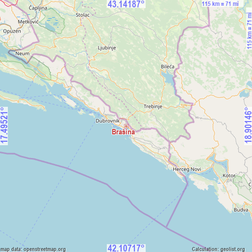
Brašina GPS coordinates[2]
42° 37' 36.012" North, 18° 11' 53.988" East
| Map corner | latitude | longitude |
|---|---|---|
| Upper-left | 43.14187°, | 17.49521° |
| Center: | 42.62667°, | 18.19833° |
| Lower-right: | 42.10717°, | 18.90146° |
| Map W x H: | 115×115 km | = 71.5×71.5mi |
| max Lat: | 46.52694° ⇑99.5% North |
| Brašina: | 42.62667° |
| min Lat: | ⇓0.5% South 42.54972° |
| min Long | Brašina | max Long |
| 13.52389° | 18.19833° | 19.37694° |
| W 85.1%⇐ | ⇒14.9% E |
Elevation
Elevation of Brašina is 58 m = 190 ft, and this is 95.3 m = 313 ft below average elevation for this country.
| Max E: |
827 m = 2713 ft | 85.9% |
| Avg. | 153.3 m = 503 ft | |
| Brašina | 58 m = 190 ft | |
Min E: |
-1 m = -3 ft | 14.1% |
See also: Croatia elevation on elevation.city.
Geographical zone
Brašina is located in North temperate zone (between Tropic of Cancer and the Arctic Circle). Distance of this Northern Tropic circle is 2133.7 km =1325.8 mi to South.| Distance of | km | miles | from Brašina |
|---|---|---|---|
| North Pole | 5267.4 | 3273 | to North |
| Arctic Circle | 2661.5 | 1653.8 | to North |
| Tropic Cancer | 2133.7 | 1325.8 | to South |
| Equator | 4739.6 | 2945 | to South |


Nearby cities:
15 places around Brašina: (largest is in red/bold)
• Cavtat
5.3 km =3.3 mi,  162°
162°
• Dubrovnik
9 km =5.6 mi,  285°
285°
• Kupari
0.9 km =0.6 mi,  218°
218°
• Mlini
0.8 km =0.5 mi,  118°
118°
• Mokošica
10.4 km =6.5 mi,  301°
301°
• Orašac
17.7 km =11 mi, 298°
• Petrača
0.8 km =0.5 mi,  326°
326°
• Podgora
38.5 km =23.9 mi,  309°
309°
• Slano
30.7 km =19.1 mi, 305°
• Srebreno
0.4 km =0.2 mi,  206°
206°
• Zaton
14.9 km =9.3 mi, 298°
• Zaton Doli
43.1 km =26.8 mi, 302°
• Zvekovica
6.5 km =4 mi,  148°
148°
• Čibača
2.2 km =1.4 mi,  276°
276°
• Čilipi
11.1 km =6.9 mi,  140°
140°
Sources, notices
• [Note1] Compared only with cities in Croatia existing in our database
• [Src1] Map data: © OpenStreetMap contributors (CC-BY-SA)
• [Src2] Other city data from geonames.org with taken over terms of usage.
• [Src3] Geographical zone / Annual Mean Temperature by Robert A. Rohde @ Wikipedia
