Chantal geodata
Chantal (Sud) is a populated place; located in Haiti in America/Port-au-Prince (GMT-4) time zone. With population of 1,848 people, there are 80 cities with bigger population in this country. Compared to other cities in Haiti, 94.3% of cities are located further ↑North; 88.7% of cities are located further →East and 58.5% of cities have lower elevation than Chantal. Note1


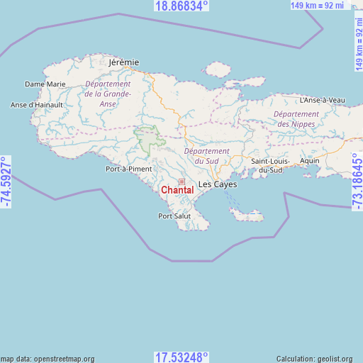
Chantal GPS coordinates[2]
18° 12' 6.084" North, 73° 53' 22.452" West
| Map corner | latitude | longitude |
|---|---|---|
| Upper-left | 18.86834°, | -74.5927° |
| Center: | 18.20169°, | -73.88957° |
| Lower-right: | 17.53248°, | -73.18645° |
| Map W x H: | 148.5×148.5 km | = 92.3×92.3mi |
| max Lat: | 19.93984° ⇑94.3% North |
| Chantal: | 18.20169° |
| min Lat: | ⇓5.7% South 18.05° |
| min Long | Chantal | max Long |
| -74.4528° | -73.88957° | -71.72475° |
| W 11.3%⇐ | ⇒88.7% E |
Elevation
Elevation of Chantal is 56 m = 184 ft, and this is 89.1 m = 292 ft below average elevation for this country.
| Max E: |
1466 m = 4810 ft | 41.5% |
| Avg. | 145.1 m = 476 ft | |
| Chantal | 56 m = 184 ft | |
Min E: |
3 m = 10 ft | 58.5% |
See also: Haiti elevation on elevation.city.
Geographical zone
Chantal is located in North Torrid zone (between Equator and Tropic of Cancer). Distance of this Northern Tropic circle is 582.1 km =361.7 mi to North.| Distance of | km | miles | from Chantal |
|---|---|---|---|
| North Pole | 7983.2 | 4960.5 | to North |
| Arctic Circle | 5377.3 | 3341.3 | to North |
| Tropic Cancer | 582.1 | 361.7 | to North |
| Equator | 2023.8 | 1257.5 | to South |


Nearby cities:
15 places around Chantal: (largest is in red/bold)
• Aquin
53 km =32.9 mi,  80°
80°
• Baradères
40.9 km =25.4 mi,  40°
40°
• Camp Perrin
14.1 km =8.8 mi,  9°
9°
• Cavaillon
27.1 km =16.8 mi,  66°
66°
• Chardonnière
30.3 km =18.8 mi,  285°
285°
• Corail
40.7 km =25.3 mi,  0°
0°
• Koto
15.9 km =9.9 mi,  271°
271°
• Les Anglais
36.7 km =22.8 mi, 288°
• Les Cayes
15.2 km =9.4 mi,  93°
93°
• Petit Trou de Nippes
54 km =33.6 mi,  48°
48°
• Port-à-Piment
22.6 km =14 mi,  283°
283°
• Roche-à-Bateau
12.2 km =7.6 mi,  259°
259°
• Saint-Jean du Sud
16.2 km =10.1 mi,  149°
149°
• Saint-Louis du Sud
36.9 km =22.9 mi, 79°
• Torbeck
9.5 km =5.9 mi,  116°
116°
Sources, notices
• [Note1] Compared only with cities in Haiti existing in our database
• [Src1] Map data: © OpenStreetMap contributors (CC-BY-SA)
• [Src2] Other city data from geonames.org with taken over terms of usage.
• [Src3] Geographical zone / Annual Mean Temperature by Robert A. Rohde @ Wikipedia
