Petit Trou de Nippes geodata
Petit Trou de Nippes (Nippes) is a populated place; located in Haiti in America/Port-au-Prince (GMT-4) time zone. With population of 2,130 people, there are 72 cities with bigger population in this country. Compared to other cities in Haiti, 67% of cities are located further ↑North; 80.2% of cities are located further →East and 98.1% of cities have higher elevation than Petit Trou de Nippes. Note1


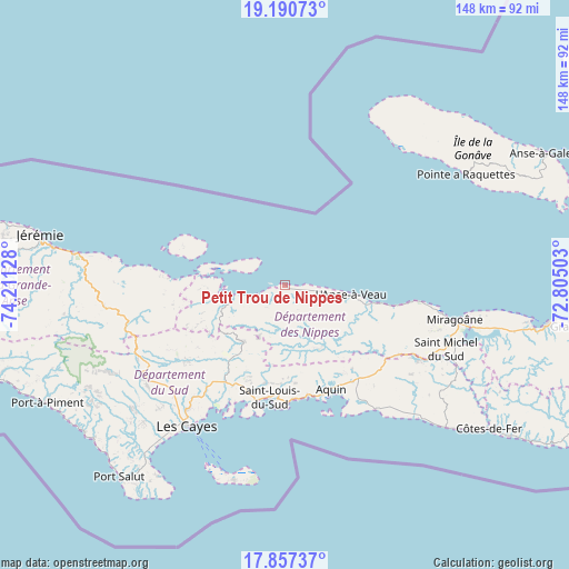
Petit Trou de Nippes GPS coordinates[2]
18° 31' 31.26" North, 73° 30' 29.34" West
| Map corner | latitude | longitude |
|---|---|---|
| Upper-left | 19.19073°, | -74.21128° |
| Center: | 18.52535°, | -73.50815° |
| Lower-right: | 17.85737°, | -72.80503° |
| Map W x H: | 148.3×148.3 km | = 92.1×92.1mi |
| max Lat: | 19.93984° ⇑67% North |
| Petit Trou de Nippes: | 18.52535° |
| min Lat: | ⇓33% South 18.05° |
| min Long | Petit Trou de N | max Long |
| -74.4528° | -73.50815° | -71.72475° |
| W 19.8%⇐ | ⇒80.2% E |
Elevation
Elevation of Petit Trou de Nippes is 6 m = 20 ft, and this is 139.1 m = 456 ft below average elevation for this country.
| Max E: |
1466 m = 4810 ft | 98.1% |
| Avg. | 145.1 m = 476 ft | |
| Petit Trou de Nippes | 6 m = 20 ft | |
Min E: |
3 m = 10 ft | 1.9% |
See also: Haiti elevation on elevation.city.
Geographical zone
Petit Trou de Nippes is located in North Torrid zone (between Equator and Tropic of Cancer). Distance of this Northern Tropic circle is 546.1 km =339.3 mi to North.| Distance of | km | miles | from Petit Trou de Nippes |
|---|---|---|---|
| North Pole | 7947.2 | 4938.2 | to North |
| Arctic Circle | 5341.3 | 3318.9 | to North |
| Tropic Cancer | 546.1 | 339.3 | to North |
| Equator | 2059.8 | 1279.9 | to South |


Nearby cities:
15 places around Petit Trou de Nippes: (largest is in red/bold)
• Anse-à-Veau
17.4 km =10.8 mi,  98°
98°
• Aquin
29.8 km =18.5 mi,  156°
156°
• Baradères
14.6 km =9.1 mi,  250°
250°
• Camp Perrin
43.9 km =27.3 mi,  239°
239°
• Cavaillon
29.4 km =18.3 mi,  211°
211°
• Chantal
54 km =33.6 mi,  228°
228°
• Corail
40.5 km =25.2 mi,  276°
276°
• Fond des Blancs
48.7 km =30.3 mi,  124°
124°
• Lazil
18.6 km =11.6 mi,  147°
147°
• Les Cayes
44.6 km =27.7 mi, 214°
• Miragoâne
45 km =28 mi, 101°
• Petite Rivière de Nippes
29.3 km =18.2 mi, 100°
• Saint-Jean du Sud
59.4 km =36.9 mi, 212°
• Saint-Louis du Sud
29.5 km =18.3 mi,  187°
187°
• Torbeck
51.3 km =31.9 mi,  218°
218°
Sources, notices
• [Note1] Compared only with cities in Haiti existing in our database
• [Src1] Map data: © OpenStreetMap contributors (CC-BY-SA)
• [Src2] Other city data from geonames.org with taken over terms of usage.
• [Src3] Geographical zone / Annual Mean Temperature by Robert A. Rohde @ Wikipedia
