Cavaillon geodata
Cavaillon (Sud) is a populated place; located in Haiti in America/Port-au-Prince (GMT-4) time zone. With population of 1,023 people, there are 101 cities with bigger population in this country. Compared to other cities in Haiti, 83% of cities are located further ↑North; 83% of cities are located further →East and 56.6% of cities have higher elevation than Cavaillon. Note1


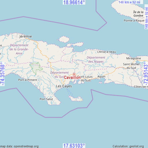
Cavaillon GPS coordinates[2]
18° 17' 59.532" North, 73° 39' 16.38" West
| Map corner | latitude | longitude |
|---|---|---|
| Upper-left | 18.96614°, | -74.35768° |
| Center: | 18.29987°, | -73.65455° |
| Lower-right: | 17.63103°, | -72.95143° |
| Map W x H: | 148.5×148.5 km | = 92.3×92.3mi |
| max Lat: | 19.93984° ⇑83% North |
| Cavaillon: | 18.29987° |
| min Lat: | ⇓17% South 18.05° |
| min Long | Cavaillon | max Long |
| -74.4528° | -73.65455° | -71.72475° |
| W 17%⇐ | ⇒83% E |
Elevation
Elevation of Cavaillon is 23 m = 75 ft, and this is 122.1 m = 401 ft below average elevation for this country.
| Max E: |
1466 m = 4810 ft | 56.6% |
| Avg. | 145.1 m = 476 ft | |
| Cavaillon | 23 m = 75 ft | |
Min E: |
3 m = 10 ft | 43.4% |
See also: Haiti elevation on elevation.city.
Geographical zone
Cavaillon is located in North Torrid zone (between Equator and Tropic of Cancer). Distance of this Northern Tropic circle is 571.2 km =354.9 mi to North.| Distance of | km | miles | from Cavaillon |
|---|---|---|---|
| North Pole | 7972.3 | 4953.8 | to North |
| Arctic Circle | 5366.4 | 3334.5 | to North |
| Tropic Cancer | 571.2 | 354.9 | to North |
| Equator | 2034.8 | 1264.4 | to South |


Nearby cities:
15 places around Cavaillon: (largest is in red/bold)
• Anse-à-Veau
39.6 km =24.6 mi,  55°
55°
• Aquin
27.6 km =17.1 mi,  94°
94°
• Baradères
20.4 km =12.7 mi,  4°
4°
• Camp Perrin
22.7 km =14.1 mi,  277°
277°
• Chantal
27.1 km =16.8 mi,  246°
246°
• Corail
38.7 km =24 mi,  320°
320°
• Koto
42 km =26.1 mi,  255°
255°
• Lazil
27 km =16.8 mi,  69°
69°
• Les Cayes
15.3 km =9.5 mi,  219°
219°
• Petit Trou de Nippes
29.4 km =18.3 mi,  31°
31°
• Port-à-Piment
47.1 km =29.3 mi, 263°
• Roche-à-Bateau
39.1 km =24.3 mi, 250°
• Saint-Jean du Sud
30 km =18.6 mi,  213°
213°
• Saint-Louis du Sud
12.2 km =7.6 mi,  109°
109°
• Torbeck
22.3 km =13.9 mi,  227°
227°
Sources, notices
• [Note1] Compared only with cities in Haiti existing in our database
• [Src1] Map data: © OpenStreetMap contributors (CC-BY-SA)
• [Src2] Other city data from geonames.org with taken over terms of usage.
• [Src3] Geographical zone / Annual Mean Temperature by Robert A. Rohde @ Wikipedia
