Villány geodata
Villány (Baranya) is a populated place; located in Hungary in Europe/Budapest (GMT+2) time zone. With population of 2,738 people, there are 556 cities with bigger population in this country. Compared to other cities in Hungary, 99.6% of cities are located further ↑North; 77.7% of cities are located further →East and 70.8% of cities have higher elevation than Villány. Note1


Villány GPS coordinates[2]
45° 52' 8.004" North, 18° 27' 14.004" East
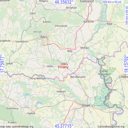
| Map corner | latitude | longitude |
|---|---|---|
| Upper-left | 46.35632°, | 17.75077° |
| Center: | 45.86889°, | 18.45389° |
| Lower-right: | 45.37715°, | 19.15702° |
| Map W x H: | 108.9×108.9 km | = 67.7×67.7mi |
| max Lat: | 48.46667° ⇑99.6% North |
| Villány: | 45.86889° |
| min Lat: | ⇓0.4% South 45.79108° |
| min Long | Villány | max Long |
| 16.27358° | 18.45389° | 22.68096° |
| W 22.3%⇐ | ⇒77.7% E |
Elevation
Elevation of Villány is 101 m = 331 ft, and this is 28.7 m = 94 ft below average elevation for this country.
| Max E: |
444 m = 1457 ft | 70.8% |
| Avg. | 129.7 m = 426 ft | |
| Villány | 101 m = 331 ft | |
Min E: |
71 m = 233 ft | 29.2% |
See also: Hungary elevation on elevation.city.
Geographical zone
Villány is located in North temperate zone (between Tropic of Cancer and the Arctic Circle). Distance of this North polar circle is 2301 km =1429.8 mi to North.| Distance of | km | miles | from Villány |
|---|---|---|---|
| North Pole | 4906.9 | 3049 | to North |
| Arctic Circle | 2301 | 1429.8 | to North |
| Tropic Cancer | 2494.2 | 1549.8 | to South |
| Equator | 5100.1 | 3169.1 | to South |


Nearby cities:
15 places around Villány: (largest is in red/bold)
• Beremend
8.8 km =5.5 mi,  190°
190°
• Báta
37.8 km =23.5 mi,  40°
40°
• Bóly
12 km =7.5 mi,  24°
24°
• Dunaszekcső
33.8 km =21 mi, 44°
• Dávod
38.5 km =23.9 mi,  68°
68°
• Harkány
16.9 km =10.5 mi,  262°
262°
• Hosszúhetény
33.8 km =21 mi,  346°
346°
• Kozármisleny
21.8 km =13.5 mi,  325°
325°
• Lánycsók
20.2 km =12.6 mi, 41°
• Mohács
22.5 km =14 mi,  53°
53°
• Pellérd
29.6 km =18.4 mi,  308°
308°
• Pécs
29.3 km =18.2 mi,  324°
324°
• Pécsvárad
32.5 km =20.2 mi,  355°
355°
• Siklós
12.2 km =7.6 mi, 262°
• Vajszló
36.4 km =22.6 mi,  268°
268°
Sources, notices
• [Note1] Compared only with cities in Hungary existing in our database
• [Src1] Map data: © OpenStreetMap contributors (CC-BY-SA)
• [Src2] Other city data from geonames.org with taken over terms of usage.
• [Src3] Geographical zone / Annual Mean Temperature by Robert A. Rohde @ Wikipedia
