Harkány geodata
Harkány (Baranya) is a populated place; located in Hungary in Europe/Budapest (GMT+2) time zone. With population of 3,450 people, there are 424 cities with bigger population in this country. Compared to other cities in Hungary, 99.9% of cities are located further ↑North; 82.3% of cities are located further →East and 80.4% of cities have higher elevation than Harkány. Note1


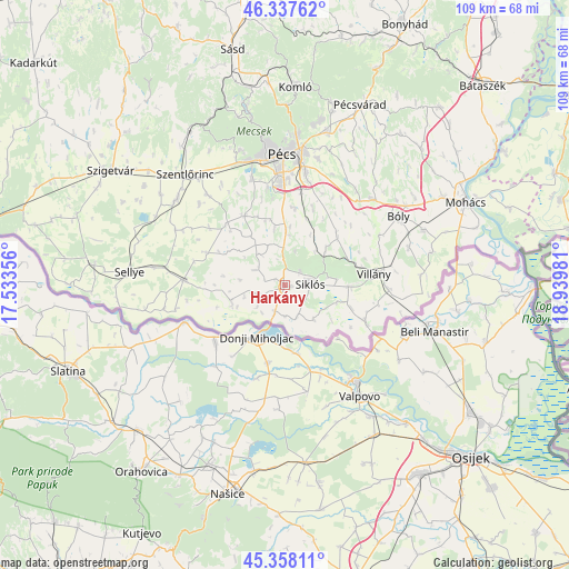
Harkány GPS coordinates[2]
45° 51' 0.072" North, 18° 14' 12.048" East
| Map corner | latitude | longitude |
|---|---|---|
| Upper-left | 46.33762°, | 17.53356° |
| Center: | 45.85002°, | 18.23668° |
| Lower-right: | 45.35811°, | 18.93981° |
| Map W x H: | 108.9×108.9 km | = 67.7×67.7mi |
| max Lat: | 48.46667° ⇑99.9% North |
| Harkány: | 45.85002° |
| min Lat: | ⇓0.1% South 45.79108° |
| min Long | Harkány | max Long |
| 16.27358° | 18.23668° | 22.68096° |
| W 17.7%⇐ | ⇒82.3% E |
Elevation
Elevation of Harkány is 95 m = 312 ft, and this is 34.7 m = 114 ft below average elevation for this country.
| Max E: |
444 m = 1457 ft | 80.4% |
| Avg. | 129.7 m = 426 ft | |
| Harkány | 95 m = 312 ft | |
Min E: |
71 m = 233 ft | 19.6% |
See also: Hungary elevation on elevation.city.
Geographical zone
Harkány is located in North temperate zone (between Tropic of Cancer and the Arctic Circle). Distance of this North polar circle is 2303.1 km =1431.1 mi to North.| Distance of | km | miles | from Harkány |
|---|---|---|---|
| North Pole | 4909 | 3050.3 | to North |
| Arctic Circle | 2303.1 | 1431.1 | to North |
| Tropic Cancer | 2492.1 | 1548.5 | to South |
| Equator | 5098 | 3167.7 | to South |


Nearby cities:
15 places around Harkány: (largest is in red/bold)
• Beremend
16.5 km =10.3 mi,  113°
113°
• Bóly
25.4 km =15.8 mi,  59°
59°
• Bükkösd
34.5 km =21.4 mi,  326°
326°
• Hosszúhetény
36 km =22.4 mi,  14°
14°
• Kozármisleny
20.4 km =12.7 mi, 12°
• Lánycsók
34.7 km =21.6 mi, 60°
• Mohács
38.1 km =23.7 mi,  65°
65°
• Pellérd
21.5 km =13.4 mi,  342°
342°
• Pécs
25.9 km =16.1 mi,  359°
359°
• Pécsvárad
37.4 km =23.2 mi,  22°
22°
• Sellye
30.3 km =18.8 mi,  274°
274°
• Siklós
4.7 km =2.9 mi,  83°
83°
• Szentlőrinc
28.6 km =17.8 mi,  317°
317°
• Vajszló
19.6 km =12.2 mi, 273°
• Villány
16.9 km =10.5 mi, 82°
Sources, notices
• [Note1] Compared only with cities in Hungary existing in our database
• [Src1] Map data: © OpenStreetMap contributors (CC-BY-SA)
• [Src2] Other city data from geonames.org with taken over terms of usage.
• [Src3] Geographical zone / Annual Mean Temperature by Robert A. Rohde @ Wikipedia
