Lánycsók geodata
Lánycsók (Baranya) is a populated place; located in Hungary in Europe/Budapest (GMT+2) time zone. With population of 2,707 people, there are 568 cities with bigger population in this country. Compared to other cities in Hungary, 98.8% of cities are located further ↑North; 75.2% of cities are located further →East and 74.5% of cities have higher elevation than Lánycsók. Note1


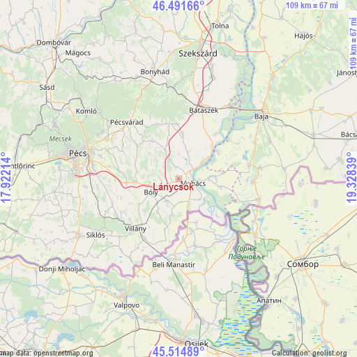
Lánycsók GPS coordinates[2]
46° 0' 19.548" North, 18° 37' 30.936" East
| Map corner | latitude | longitude |
|---|---|---|
| Upper-left | 46.49166°, | 17.92214° |
| Center: | 46.00543°, | 18.62526° |
| Lower-right: | 45.51489°, | 19.32839° |
| Map W x H: | 108.6×108.6 km | = 67.5×67.5mi |
| max Lat: | 48.46667° ⇑98.8% North |
| Lánycsók: | 46.00543° |
| min Lat: | ⇓1.2% South 45.79108° |
| min Long | Lánycsók | max Long |
| 16.27358° | 18.62526° | 22.68096° |
| W 24.8%⇐ | ⇒75.2% E |
Elevation
Elevation of Lánycsók is 99 m = 325 ft, and this is 30.7 m = 101 ft below average elevation for this country.
| Max E: |
444 m = 1457 ft | 74.5% |
| Avg. | 129.7 m = 426 ft | |
| Lánycsók | 99 m = 325 ft | |
Min E: |
71 m = 233 ft | 25.5% |
See also: Hungary elevation on elevation.city.
Geographical zone
Lánycsók is located in North temperate zone (between Tropic of Cancer and the Arctic Circle). Distance of this North polar circle is 2285.8 km =1420.3 mi to North.| Distance of | km | miles | from Lánycsók |
|---|---|---|---|
| North Pole | 4891.7 | 3039.6 | to North |
| Arctic Circle | 2285.8 | 1420.3 | to North |
| Tropic Cancer | 2509.4 | 1559.3 | to South |
| Equator | 5115.3 | 3178.5 | to South |


Nearby cities:
15 places around Lánycsók: (largest is in red/bold)
• Beremend
28.1 km =17.5 mi,  212°
212°
• Báta
17.7 km =11 mi,  39°
39°
• Bátaszék
22.3 km =13.9 mi,  19°
19°
• Bóly
9.3 km =5.8 mi,  242°
242°
• Dunaszekcső
13.8 km =8.6 mi,  48°
48°
• Dávod
22.6 km =14 mi,  92°
92°
• Hercegszántó
25 km =15.5 mi,  104°
104°
• Hidas
29.7 km =18.5 mi,  340°
340°
• Hosszúhetény
27.6 km =17.1 mi,  309°
309°
• Kozármisleny
25.9 km =16.1 mi,  275°
275°
• Mecseknádasd
27.1 km =16.8 mi,  333°
333°
• Mohács
5 km =3.1 mi,  109°
109°
• Nagybaracska
22.1 km =13.7 mi,  79°
79°
• Pécsvárad
23.2 km =14.4 mi,  317°
317°
• Villány
20.2 km =12.6 mi,  221°
221°
Sources, notices
• [Note1] Compared only with cities in Hungary existing in our database
• [Src1] Map data: © OpenStreetMap contributors (CC-BY-SA)
• [Src2] Other city data from geonames.org with taken over terms of usage.
• [Src3] Geographical zone / Annual Mean Temperature by Robert A. Rohde @ Wikipedia
