Sárbogárd geodata
Sárbogárd (Fejér) is a populated place; located in Hungary in Europe/Budapest (GMT+2) time zone. With population of 13,424 people, there are 122 cities with bigger population in this country. Compared to other cities in Hungary, 72.8% of cities are located further ↑North; 75.3% of cities are located further →East and 63.9% of cities have higher elevation than Sárbogárd. Note1


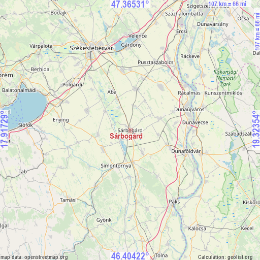
Sárbogárd GPS coordinates[2]
46° 53' 12.912" North, 18° 37' 13.476" East
| Map corner | latitude | longitude |
|---|---|---|
| Upper-left | 47.36531°, | 17.91729° |
| Center: | 46.88692°, | 18.62041° |
| Lower-right: | 46.40422°, | 19.32354° |
| Map W x H: | 106.9×106.9 km | = 66.4×66.4mi |
| max Lat: | 48.46667° ⇑72.8% North |
| Sárbogárd: | 46.88692° |
| min Lat: | ⇓27.2% South 45.79108° |
| min Long | Sárbogárd | max Long |
| 16.27358° | 18.62041° | 22.68096° |
| W 24.7%⇐ | ⇒75.3% E |
Elevation
Elevation of Sárbogárd is 107 m = 351 ft, and this is 22.7 m = 74 ft below average elevation for this country.
| Max E: |
444 m = 1457 ft | 63.9% |
| Avg. | 129.7 m = 426 ft | |
| Sárbogárd | 107 m = 351 ft | |
Min E: |
71 m = 233 ft | 36.1% |
See also: Hungary elevation on elevation.city.
Geographical zone
Sárbogárd is located in North temperate zone (between Tropic of Cancer and the Arctic Circle). Distance of this North polar circle is 2187.8 km =1359.4 mi to North.| Distance of | km | miles | from Sárbogárd |
|---|---|---|---|
| North Pole | 4793.7 | 2978.7 | to North |
| Arctic Circle | 2187.8 | 1359.4 | to North |
| Tropic Cancer | 2607.4 | 1620.2 | to South |
| Equator | 5213.3 | 3239.4 | to South |


Nearby cities:
15 places around Sárbogárd: (largest is in red/bold)
• Aba
17.5 km =10.9 mi,  334°
334°
• Alap
11.1 km =6.9 mi,  151°
151°
• Baracs
21.8 km =13.5 mi,  91°
91°
• Cece
13 km =8.1 mi,  177°
177°
• Dég
13.1 km =8.1 mi,  260°
260°
• Előszállás
17.4 km =10.8 mi,  110°
110°
• Kisláng
19.3 km =12 mi,  293°
293°
• Káloz
12.9 km =8 mi,  305°
305°
• Mezőfalva
12.5 km =7.8 mi,  66°
66°
• Mezőszilas
13.7 km =8.5 mi,  232°
232°
• Perkáta
21.8 km =13.5 mi,  35°
35°
• Simontornya
15.5 km =9.6 mi,  198°
198°
• Soponya
19.1 km =11.9 mi,  318°
318°
• Sárkeresztúr
14.4 km =8.9 mi,  336°
336°
• Sárosd
17.4 km =10.8 mi,  5°
5°
Sources, notices
• [Note1] Compared only with cities in Hungary existing in our database
• [Src1] Map data: © OpenStreetMap contributors (CC-BY-SA)
• [Src2] Other city data from geonames.org with taken over terms of usage.
• [Src3] Geographical zone / Annual Mean Temperature by Robert A. Rohde @ Wikipedia
