Sárosd geodata
Sárosd (Fejér) is a populated place; located in Hungary in Europe/Budapest (GMT+2) time zone. With population of 3,474 people, there are 419 cities with bigger population in this country. Compared to other cities in Hungary, 67.4% of cities are located further ↑North; 74.7% of cities are located further →East and 50.7% of cities have lower elevation than Sárosd. Note1


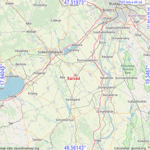
Sárosd GPS coordinates[2]
47° 2' 33.828" North, 18° 38' 36.852" East
| Map corner | latitude | longitude |
|---|---|---|
| Upper-left | 47.51973°, | 17.94045° |
| Center: | 47.04273°, | 18.64357° |
| Lower-right: | 46.56143°, | 19.3467° |
| Map W x H: | 106.6×106.6 km | = 66.2×66.2mi |
| max Lat: | 48.46667° ⇑67.4% North |
| Sárosd: | 47.04273° |
| min Lat: | ⇓32.6% South 45.79108° |
| min Long | Sárosd | max Long |
| 16.27358° | 18.64357° | 22.68096° |
| W 25.3%⇐ | ⇒74.7% E |
Elevation
Elevation of Sárosd is 116 m = 381 ft, and this is 13.7 m = 45 ft below average elevation for this country.
| Max E: |
444 m = 1457 ft | 49.3% |
| Avg. | 129.7 m = 426 ft | |
| Sárosd | 116 m = 381 ft | |
Min E: |
71 m = 233 ft | 50.7% |
See also: Hungary elevation on elevation.city.
Geographical zone
Sárosd is located in North temperate zone (between Tropic of Cancer and the Arctic Circle). Distance of this North polar circle is 2170.5 km =1348.7 mi to North.| Distance of | km | miles | from Sárosd |
|---|---|---|---|
| North Pole | 4776.4 | 2967.9 | to North |
| Arctic Circle | 2170.5 | 1348.7 | to North |
| Tropic Cancer | 2624.7 | 1630.9 | to South |
| Equator | 5230.7 | 3250.2 | to South |


Nearby cities:
15 places around Sárosd: (largest is in red/bold)
• Aba
9.4 km =5.8 mi,  260°
260°
• Adony
18.8 km =11.7 mi,  63°
63°
• Gárdony
18.5 km =11.5 mi,  358°
358°
• Iváncsa
18.4 km =11.4 mi,  46°
46°
• Kisláng
21.6 km =13.4 mi,  243°
243°
• Káloz
15.7 km =9.8 mi,  231°
231°
• Mezőfalva
15.7 km =9.8 mi,  141°
141°
• Perkáta
10.9 km =6.8 mi,  87°
87°
• Pusztaszabolcs
14.1 km =8.8 mi,  41°
41°
• Pákozd
20.8 km =12.9 mi,  336°
336°
• Seregélyes
9.6 km =6 mi,  321°
321°
• Soponya
14.7 km =9.1 mi, 257°
• Sárbogárd
17.4 km =10.8 mi,  185°
185°
• Sárkeresztúr
8.6 km =5.3 mi, 241°
• Velence
21.8 km =13.5 mi,  2°
2°
Sources, notices
• [Note1] Compared only with cities in Hungary existing in our database
• [Src1] Map data: © OpenStreetMap contributors (CC-BY-SA)
• [Src2] Other city data from geonames.org with taken over terms of usage.
• [Src3] Geographical zone / Annual Mean Temperature by Robert A. Rohde @ Wikipedia
