Gomba geodata
Gomba (Pest) is a populated place; located in Hungary in Europe/Budapest (GMT+2) time zone. With population of 2,861 people, there are 522 cities with bigger population in this country. Compared to other cities in Hungary, 52.8% of cities are located further ↑North; 50.7% of cities are located further ←West and 79.5% of cities have lower elevation than Gomba. Note1


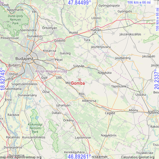
Gomba GPS coordinates[2]
47° 22' 15.42" North, 19° 31' 50.052" East
| Map corner | latitude | longitude |
|---|---|---|
| Upper-left | 47.84499°, | 18.82745° |
| Center: | 47.37095°, | 19.53057° |
| Lower-right: | 46.89261°, | 20.2337° |
| Map W x H: | 105.9×105.9 km | = 65.8×65.8mi |
| max Lat: | 48.46667° ⇑52.8% North |
| Gomba: | 47.37095° |
| min Lat: | ⇓47.2% South 45.79108° |
| min Long | Gomba | max Long |
| 16.27358° | 19.53057° | 22.68096° |
| W 50.7%⇐ | ⇒49.3% E |
Elevation
Elevation of Gomba is 156 m = 512 ft, and this is 26.3 m = 86 ft above average elevation for this country.
| Max E: |
444 m = 1457 ft | 20.5% |
| Gomba | 156 m 512 ft | |
| Avg. | 129.7 m = 426 ft | |
Min E: |
71 m = 233 ft | 79.5% |
See also: Hungary elevation on elevation.city.
Geographical zone
Gomba is located in North temperate zone (between Tropic of Cancer and the Arctic Circle). Distance of this North polar circle is 2134 km =1326 mi to North.| Distance of | km | miles | from Gomba |
|---|---|---|---|
| North Pole | 4739.9 | 2945.2 | to North |
| Arctic Circle | 2134 | 1326 | to North |
| Tropic Cancer | 2661.2 | 1653.6 | to South |
| Equator | 5267.2 | 3272.9 | to South |


Nearby cities:
15 places around Gomba: (largest is in red/bold)
• Forrópuszta
13.5 km =8.4 mi,  46°
46°
• Gyömrő
11.6 km =7.2 mi,  302°
302°
• Kóka
13.2 km =8.2 mi,  15°
15°
• Mende
8.7 km =5.4 mi,  320°
320°
• Monor
6.6 km =4.1 mi,  250°
250°
• Nyáregyháza
12.3 km =7.6 mi,  190°
190°
• Pilis
9.2 km =5.7 mi,  171°
171°
• Pánd
8.2 km =5.1 mi,  103°
103°
• Péteri
9.4 km =5.8 mi,  283°
283°
• Sülysáp
9 km =5.6 mi,  1°
1°
• Tápióbicske
11.8 km =7.3 mi, 95°
• Tápiószecső
10.6 km =6.6 mi,  33°
33°
• Tápióság
8.3 km =5.2 mi,  65°
65°
• Úri
4.8 km =3 mi,  357°
357°
• Üllő
13.3 km =8.3 mi, 278°
Sources, notices
• [Note1] Compared only with cities in Hungary existing in our database
• [Src1] Map data: © OpenStreetMap contributors (CC-BY-SA)
• [Src2] Other city data from geonames.org with taken over terms of usage.
• [Src3] Geographical zone / Annual Mean Temperature by Robert A. Rohde @ Wikipedia
