Péteri geodata
Péteri (Pest) is a populated place; located in Hungary in Europe/Budapest (GMT+2) time zone. With population of 1,970 people, there are 802 cities with bigger population in this country. Compared to other cities in Hungary, 51.5% of cities are located further ↑North; 51.9% of cities are located further →East and 81% of cities have lower elevation than Péteri. Note1


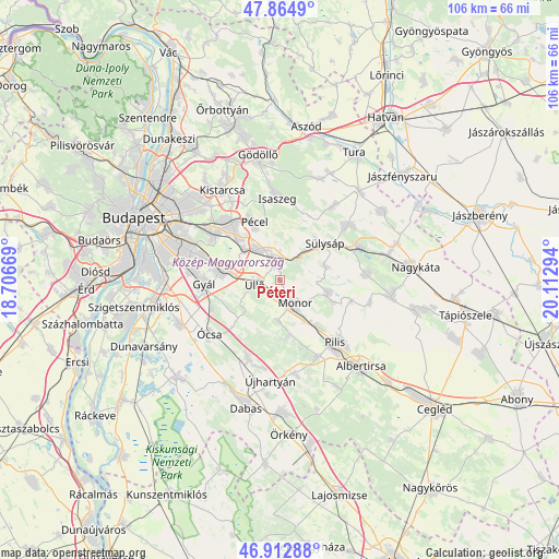
Péteri GPS coordinates[2]
47° 23' 27.744" North, 19° 24' 35.316" East
| Map corner | latitude | longitude |
|---|---|---|
| Upper-left | 47.8649°, | 18.70669° |
| Center: | 47.39104°, | 19.40981° |
| Lower-right: | 46.91288°, | 20.11294° |
| Map W x H: | 105.9×105.9 km | = 65.8×65.8mi |
| max Lat: | 48.46667° ⇑51.5% North |
| Péteri: | 47.39104° |
| min Lat: | ⇓48.5% South 45.79108° |
| min Long | Péteri | max Long |
| 16.27358° | 19.40981° | 22.68096° |
| W 48.1%⇐ | ⇒51.9% E |
Elevation
Elevation of Péteri is 159 m = 522 ft, and this is 29.3 m = 96 ft above average elevation for this country.
| Max E: |
444 m = 1457 ft | 19% |
| Péteri | 159 m 522 ft | |
| Avg. | 129.7 m = 426 ft | |
Min E: |
71 m = 233 ft | 81% |
See also: Hungary elevation on elevation.city.
Geographical zone
Péteri is located in North temperate zone (between Tropic of Cancer and the Arctic Circle). Distance of this North polar circle is 2131.8 km =1324.6 mi to North.| Distance of | km | miles | from Péteri |
|---|---|---|---|
| North Pole | 4737.7 | 2943.9 | to North |
| Arctic Circle | 2131.8 | 1324.6 | to North |
| Tropic Cancer | 2663.5 | 1655 | to South |
| Equator | 5269.4 | 3274.3 | to South |


Nearby cities:
15 places around Péteri: (largest is in red/bold)
• Budapest XVII. kerület
15.3 km =9.5 mi,  310°
310°
• Ecser
8.7 km =5.4 mi, 312°
• Felsőpakony
14.1 km =8.8 mi,  247°
247°
• Gomba
9.4 km =5.8 mi,  103°
103°
• Gyál
14.2 km =8.8 mi,  267°
267°
• Gyömrő
4.1 km =2.5 mi,  351°
351°
• Maglód
6.7 km =4.2 mi,  329°
329°
• Mende
5.7 km =3.5 mi,  37°
37°
• Monor
5.2 km =3.2 mi,  147°
147°
• Pilis
15.4 km =9.6 mi,  137°
137°
• Pécel
12.1 km =7.5 mi, 334°
• Sülysáp
11.5 km =7.1 mi,  53°
53°
• Vecsés
9.5 km =5.9 mi,  280°
280°
• Úri
9.2 km =5.7 mi,  73°
73°
• Üllő
4.1 km =2.5 mi,  264°
264°
Sources, notices
• [Note1] Compared only with cities in Hungary existing in our database
• [Src1] Map data: © OpenStreetMap contributors (CC-BY-SA)
• [Src2] Other city data from geonames.org with taken over terms of usage.
• [Src3] Geographical zone / Annual Mean Temperature by Robert A. Rohde @ Wikipedia
