Monor geodata
Monor (Pest) is a seat of a second-order administrative division; located in Hungary in Europe/Budapest (GMT+2) time zone. With population of 21,720 people, there are 78 cities with bigger population in this country. Compared to other cities in Hungary, 53.9% of cities are located further ↑North; 51.2% of cities are located further →East and 69.8% of cities have lower elevation than Monor. Note1


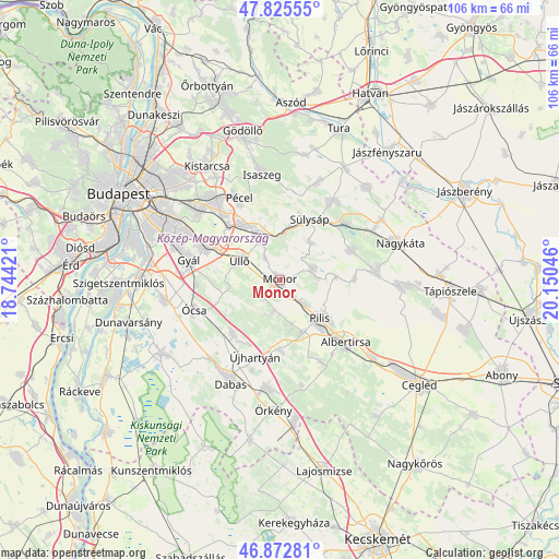
Monor GPS coordinates[2]
47° 21' 4.788" North, 19° 26' 50.388" East
| Map corner | latitude | longitude |
|---|---|---|
| Upper-left | 47.82555°, | 18.74421° |
| Center: | 47.35133°, | 19.44733° |
| Lower-right: | 46.87281°, | 20.15046° |
| Map W x H: | 105.9×105.9 km | = 65.8×65.8mi |
| max Lat: | 48.46667° ⇑53.9% North |
| Monor: | 47.35133° |
| min Lat: | ⇓46.1% South 45.79108° |
| min Long | Monor | max Long |
| 16.27358° | 19.44733° | 22.68096° |
| W 48.8%⇐ | ⇒51.2% E |
Elevation
Elevation of Monor is 137 m = 449 ft, and this is 7.3 m = 24 ft above average elevation for this country.
| Max E: |
444 m = 1457 ft | 30.2% |
| Monor | 137 m 449 ft | |
| Avg. | 129.7 m = 426 ft | |
Min E: |
71 m = 233 ft | 69.8% |
See also: Hungary elevation on elevation.city.
Geographical zone
Monor is located in North temperate zone (between Tropic of Cancer and the Arctic Circle). Distance of this North polar circle is 2136.2 km =1327.4 mi to North.| Distance of | km | miles | from Monor |
|---|---|---|---|
| North Pole | 4742.1 | 2946.6 | to North |
| Arctic Circle | 2136.2 | 1327.4 | to North |
| Tropic Cancer | 2659.1 | 1652.3 | to South |
| Equator | 5265 | 3271.5 | to South |


Nearby cities:
15 places around Monor: (largest is in red/bold)
• Ecser
13.8 km =8.6 mi,  318°
318°
• Gomba
6.6 km =4.1 mi,  70°
70°
• Gyömrő
9.1 km =5.7 mi,  337°
337°
• Inárcs
13.5 km =8.4 mi,  222°
222°
• Kakucs
13.7 km =8.5 mi,  207°
207°
• Maglód
11.9 km =7.4 mi,  328°
328°
• Mende
8.9 km =5.5 mi,  4°
4°
• Nyáregyháza
10.8 km =6.7 mi,  157°
157°
• Pilis
10.3 km =6.4 mi,  132°
132°
• Pánd
14.2 km =8.8 mi,  89°
89°
• Péteri
5.2 km =3.2 mi, 327°
• Sülysáp
12.9 km =8 mi,  30°
30°
• Vecsés
13.6 km =8.5 mi,  297°
297°
• Úri
9.2 km =5.7 mi,  40°
40°
• Üllő
8 km =5 mi, 300°
Sources, notices
• [Note1] Compared only with cities in Hungary existing in our database
• [Src1] Map data: © OpenStreetMap contributors (CC-BY-SA)
• [Src2] Other city data from geonames.org with taken over terms of usage.
• [Src3] Geographical zone / Annual Mean Temperature by Robert A. Rohde @ Wikipedia
