Vésztő geodata
Vésztő (Bekes) is a populated place; located in Hungary in Europe/Budapest (GMT+2) time zone. With population of 7,494 people, there are 208 cities with bigger population in this country. Compared to other cities in Hungary, 71.9% of cities are located further ↑North; 85.3% of cities are located further ←West and 96.4% of cities have higher elevation than Vésztő. Note1


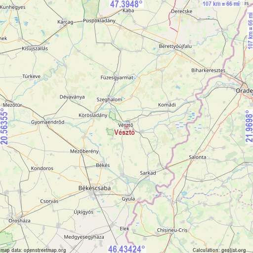
Vésztő GPS coordinates[2]
46° 55' 0.012" North, 21° 16' 0.012" East
| Map corner | latitude | longitude |
|---|---|---|
| Upper-left | 47.3948°, | 20.56355° |
| Center: | 46.91667°, | 21.26667° |
| Lower-right: | 46.43424°, | 21.9698° |
| Map W x H: | 106.8×106.8 km | = 66.4×66.4mi |
| max Lat: | 48.46667° ⇑71.9% North |
| Vésztő: | 46.91667° |
| min Lat: | ⇓28.1% South 45.79108° |
| min Long | Vésztő | max Long |
| 16.27358° | 21.26667° | 22.68096° |
| W 85.3%⇐ | ⇒14.7% E |
Elevation
Elevation of Vésztő is 83 m = 272 ft, and this is 46.7 m = 153 ft below average elevation for this country.
| Max E: |
444 m = 1457 ft | 96.4% |
| Avg. | 129.7 m = 426 ft | |
| Vésztő | 83 m = 272 ft | |
Min E: |
71 m = 233 ft | 3.6% |
See also: Hungary elevation on elevation.city.
Geographical zone
Vésztő is located in North temperate zone (between Tropic of Cancer and the Arctic Circle). Distance of this North polar circle is 2184.5 km =1357.4 mi to North.| Distance of | km | miles | from Vésztő |
|---|---|---|---|
| North Pole | 4790.4 | 2976.6 | to North |
| Arctic Circle | 2184.5 | 1357.4 | to North |
| Tropic Cancer | 2610.7 | 1622.2 | to South |
| Equator | 5216.6 | 3241.4 | to South |


Nearby cities:
15 places around Vésztő: (largest is in red/bold)
• Békés
19.5 km =12.1 mi,  211°
211°
• Békéscsaba
28.9 km =18 mi, 206°
• Csökmő
13.2 km =8.2 mi,  11°
11°
• Doboz
20.4 km =12.7 mi,  183°
183°
• Dévaványa
26.2 km =16.3 mi,  299°
299°
• Füzesgyarmat
20.7 km =12.9 mi,  349°
349°
• Gyula
29.7 km =18.5 mi, 177°
• Komádi
20 km =12.4 mi,  62°
62°
• Körösladány
15 km =9.3 mi,  291°
291°
• Köröstarcsa
18.1 km =11.2 mi,  258°
258°
• Mezőberény
20.9 km =13 mi,  237°
237°
• Méhkerék
20.4 km =12.7 mi,  136°
136°
• Okány
6.6 km =4.1 mi,  106°
106°
• Sarkad
20.5 km =12.7 mi,  154°
154°
• Szeghalom
15 km =9.3 mi,  329°
329°
Sources, notices
• [Note1] Compared only with cities in Hungary existing in our database
• [Src1] Map data: © OpenStreetMap contributors (CC-BY-SA)
• [Src2] Other city data from geonames.org with taken over terms of usage.
• [Src3] Geographical zone / Annual Mean Temperature by Robert A. Rohde @ Wikipedia
