Okány geodata
Okány (Bekes) is a populated place; located in Hungary in Europe/Budapest (GMT+2) time zone. With population of 2,930 people, there are 516 cities with bigger population in this country. Compared to other cities in Hungary, 72.6% of cities are located further ↑North; 86.2% of cities are located further ←West and 89.4% of cities have higher elevation than Okány. Note1


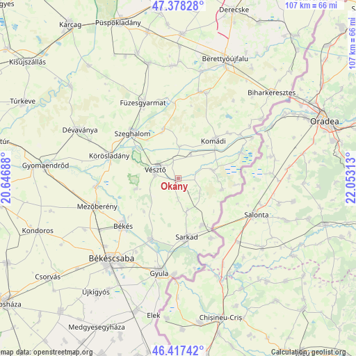
Okány GPS coordinates[2]
46° 54' 0" North, 21° 21' 0" East
| Map corner | latitude | longitude |
|---|---|---|
| Upper-left | 47.37828°, | 20.64688° |
| Center: | 46.9°, | 21.35° |
| Lower-right: | 46.41742°, | 22.05313° |
| Map W x H: | 106.8×106.8 km | = 66.4×66.4mi |
| max Lat: | 48.46667° ⇑72.6% North |
| Okány: | 46.9° |
| min Lat: | ⇓27.4% South 45.79108° |
| min Long | Okány | max Long |
| 16.27358° | 21.35° | 22.68096° |
| W 86.2%⇐ | ⇒13.8% E |
Elevation
Elevation of Okány is 87 m = 285 ft, and this is 42.7 m = 140 ft below average elevation for this country.
| Max E: |
444 m = 1457 ft | 89.4% |
| Avg. | 129.7 m = 426 ft | |
| Okány | 87 m = 285 ft | |
Min E: |
71 m = 233 ft | 10.6% |
See also: Hungary elevation on elevation.city.
Geographical zone
Okány is located in North temperate zone (between Tropic of Cancer and the Arctic Circle). Distance of this North polar circle is 2186.4 km =1358.6 mi to North.| Distance of | km | miles | from Okány |
|---|---|---|---|
| North Pole | 4792.3 | 2977.8 | to North |
| Arctic Circle | 2186.4 | 1358.6 | to North |
| Tropic Cancer | 2608.9 | 1621.1 | to South |
| Equator | 5214.8 | 3240.3 | to South |


Nearby cities:
15 places around Okány: (largest is in red/bold)
• Békés
22.2 km =13.8 mi,  228°
228°
• Békéscsaba
30.7 km =19.1 mi,  218°
218°
• Csökmő
15.3 km =9.5 mi,  345°
345°
• Doboz
20 km =12.4 mi,  202°
202°
• Dévaványa
32.6 km =20.3 mi,  297°
297°
• Füzesgyarmat
24.4 km =15.2 mi,  335°
335°
• Gyula
28.3 km =17.6 mi,  190°
190°
• Komádi
15.9 km =9.9 mi,  45°
45°
• Körösladány
21.6 km =13.4 mi,  290°
290°
• Köröstarcsa
24.1 km =15 mi,  265°
265°
• Mezőberény
25.8 km =16 mi,  248°
248°
• Méhkerék
15 km =9.3 mi,  149°
149°
• Sarkad
16.9 km =10.5 mi,  171°
171°
• Szeghalom
20.3 km =12.6 mi,  316°
316°
• Vésztő
6.6 km =4.1 mi, 286°
Sources, notices
• [Note1] Compared only with cities in Hungary existing in our database
• [Src1] Map data: © OpenStreetMap contributors (CC-BY-SA)
• [Src2] Other city data from geonames.org with taken over terms of usage.
• [Src3] Geographical zone / Annual Mean Temperature by Robert A. Rohde @ Wikipedia
