Gyula geodata
Gyula (Bekes) is a seat of a second-order administrative division; located in Hungary in Europe/Budapest (GMT+2) time zone. With population of 32,269 people, there are 54 cities with bigger population in this country. Compared to other cities in Hungary, 81.8% of cities are located further ↑North; 85.7% of cities are located further ←West and 91.3% of cities have higher elevation than Gyula. Note1


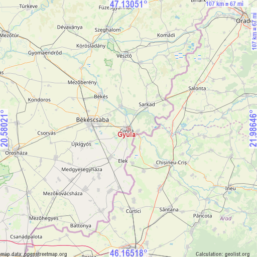
Gyula GPS coordinates[2]
46° 39' 0" North, 21° 16' 59.988" East
| Map corner | latitude | longitude |
|---|---|---|
| Upper-left | 47.13051°, | 20.58021° |
| Center: | 46.65°, | 21.28333° |
| Lower-right: | 46.16518°, | 21.98646° |
| Map W x H: | 107.3×107.3 km | = 66.7×66.7mi |
| max Lat: | 48.46667° ⇑81.8% North |
| Gyula: | 46.65° |
| min Lat: | ⇓18.2% South 45.79108° |
| min Long | Gyula | max Long |
| 16.27358° | 21.28333° | 22.68096° |
| W 85.7%⇐ | ⇒14.3% E |
Elevation
Elevation of Gyula is 86 m = 282 ft, and this is 43.7 m = 143 ft below average elevation for this country.
| Max E: |
444 m = 1457 ft | 91.3% |
| Avg. | 129.7 m = 426 ft | |
| Gyula | 86 m = 282 ft | |
Min E: |
71 m = 233 ft | 8.7% |
See also: Hungary elevation on elevation.city.
Geographical zone
Gyula is located in North temperate zone (between Tropic of Cancer and the Arctic Circle). Distance of this North polar circle is 2214.2 km =1375.8 mi to North.| Distance of | km | miles | from Gyula |
|---|---|---|---|
| North Pole | 4820.1 | 2995.1 | to North |
| Arctic Circle | 2214.2 | 1375.8 | to North |
| Tropic Cancer | 2581.1 | 1603.8 | to South |
| Equator | 5187 | 3223.1 | to South |


Nearby cities:
15 places around Gyula: (largest is in red/bold)
• Békés
17.3 km =10.7 mi,  318°
318°
• Békéscsaba
14.5 km =9 mi,  284°
284°
• Doboz
9.6 km =6 mi,  344°
344°
• Elek
13.2 km =8.2 mi,  191°
191°
• Kevermes
27 km =16.8 mi,  196°
196°
• Kétegyháza
15.1 km =9.4 mi,  210°
210°
• Lőkösháza
24.4 km =15.2 mi, 189°
• Medgyesegyháza
25.4 km =15.8 mi,  228°
228°
• Mezőberény
26.6 km =16.5 mi,  314°
314°
• Méhkerék
19.5 km =12.1 mi,  40°
40°
• Okány
28.3 km =17.6 mi,  10°
10°
• Sarkad
13.5 km =8.4 mi,  34°
34°
• Szabadkígyós
14.5 km =9 mi,  255°
255°
• Vésztő
29.7 km =18.5 mi,  357°
357°
• Újkígyós
20.5 km =12.7 mi,  248°
248°
Sources, notices
• [Note1] Compared only with cities in Hungary existing in our database
• [Src1] Map data: © OpenStreetMap contributors (CC-BY-SA)
• [Src2] Other city data from geonames.org with taken over terms of usage.
• [Src3] Geographical zone / Annual Mean Temperature by Robert A. Rohde @ Wikipedia
