Törökszentmiklós geodata
Törökszentmiklós (Jász-Nagykun-Szolnok) is a seat of a second-order administrative division; located in Hungary in Europe/Budapest (GMT+2) time zone. With population of 22,770 people, there are 74 cities with bigger population in this country. Compared to other cities in Hungary, 62.8% of cities are located further ↑North; 69.9% of cities are located further ←West and 97.3% of cities have higher elevation than Törökszentmiklós. Note1


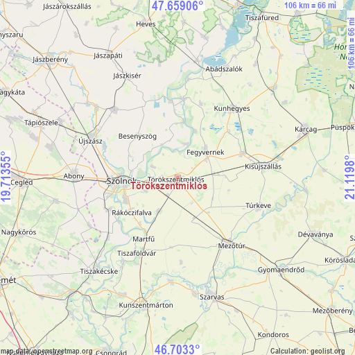
Törökszentmiklós GPS coordinates[2]
47° 10' 59.988" North, 20° 25' 0.012" East
| Map corner | latitude | longitude |
|---|---|---|
| Upper-left | 47.65906°, | 19.71355° |
| Center: | 47.18333°, | 20.41667° |
| Lower-right: | 46.7033°, | 21.1198° |
| Map W x H: | 106.3×106.3 km | = 66.1×66.1mi |
| max Lat: | 48.46667° ⇑62.8% North |
| Törökszentmiklós: | 47.18333° |
| min Lat: | ⇓37.2% South 45.79108° |
| min Long | Törökszentmik | max Long |
| 16.27358° | 20.41667° | 22.68096° |
| W 69.9%⇐ | ⇒30.1% E |
Elevation
Elevation of Törökszentmiklós is 82 m = 269 ft, and this is 47.7 m = 156 ft below average elevation for this country.
| Max E: |
444 m = 1457 ft | 97.3% |
| Avg. | 129.7 m = 426 ft | |
| Törökszentmiklós | 82 m = 269 ft | |
Min E: |
71 m = 233 ft | 2.7% |
See also: Hungary elevation on elevation.city.
Geographical zone
Törökszentmiklós is located in North temperate zone (between Tropic of Cancer and the Arctic Circle). Distance of this North polar circle is 2154.9 km =1339 mi to North.| Distance of | km | miles | from Törökszentmiklós |
|---|---|---|---|
| North Pole | 4760.8 | 2958.2 | to North |
| Arctic Circle | 2154.9 | 1339 | to North |
| Tropic Cancer | 2640.4 | 1640.7 | to South |
| Equator | 5246.3 | 3259.9 | to South |


Nearby cities:
15 places around Törökszentmiklós: (largest is in red/bold)
• Besenyszög
17.2 km =10.7 mi,  318°
318°
• Fegyvernek
12.8 km =8 mi,  43°
43°
• Kenderes
21.5 km =13.4 mi,  69°
69°
• Kengyel
12.8 km =8 mi,  209°
209°
• Rákóczifalva
17.8 km =11.1 mi,  231°
231°
• Rákócziújfalu
17.2 km =10.7 mi,  221°
221°
• Szajol
8.8 km =5.5 mi,  270°
270°
• Szolnok
16.4 km =10.2 mi, 270°
• Tiszabő
13.9 km =8.6 mi,  21°
21°
• Tiszaföldvár
25.6 km =15.9 mi, 209°
• Tiszapüspöki
8.4 km =5.2 mi,  296°
296°
• Tiszaroff
24.2 km =15 mi,  5°
5°
• Tiszasüly
22.3 km =13.9 mi,  356°
356°
• Tószeg
22.2 km =13.8 mi,  245°
245°
• Zagyvarékas
23.3 km =14.5 mi,  293°
293°
Sources, notices
• [Note1] Compared only with cities in Hungary existing in our database
• [Src1] Map data: © OpenStreetMap contributors (CC-BY-SA)
• [Src2] Other city data from geonames.org with taken over terms of usage.
• [Src3] Geographical zone / Annual Mean Temperature by Robert A. Rohde @ Wikipedia
