Fegyvernek geodata
Fegyvernek (Jász-Nagykun-Szolnok) is a populated place; located in Hungary in Europe/Budapest (GMT+2) time zone. With population of 6,972 people, there are 220 cities with bigger population in this country. Compared to other cities in Hungary, 58.4% of cities are located further ↑North; 72% of cities are located further ←West and 94.4% of cities have higher elevation than Fegyvernek. Note1


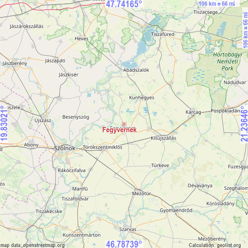
Fegyvernek GPS coordinates[2]
47° 16' 0.012" North, 20° 31' 59.988" East
| Map corner | latitude | longitude |
|---|---|---|
| Upper-left | 47.74165°, | 19.83021° |
| Center: | 47.26667°, | 20.53333° |
| Lower-right: | 46.78739°, | 21.23646° |
| Map W x H: | 106.1×106.1 km | = 65.9×65.9mi |
| max Lat: | 48.46667° ⇑58.4% North |
| Fegyvernek: | 47.26667° |
| min Lat: | ⇓41.6% South 45.79108° |
| min Long | Fegyvernek | max Long |
| 16.27358° | 20.53333° | 22.68096° |
| W 72%⇐ | ⇒28% E |
Elevation
Elevation of Fegyvernek is 84 m = 276 ft, and this is 45.7 m = 150 ft below average elevation for this country.
| Max E: |
444 m = 1457 ft | 94.4% |
| Avg. | 129.7 m = 426 ft | |
| Fegyvernek | 84 m = 276 ft | |
Min E: |
71 m = 233 ft | 5.6% |
See also: Hungary elevation on elevation.city.
Geographical zone
Fegyvernek is located in North temperate zone (between Tropic of Cancer and the Arctic Circle). Distance of this North polar circle is 2145.6 km =1333.2 mi to North.| Distance of | km | miles | from Fegyvernek |
|---|---|---|---|
| North Pole | 4751.5 | 2952.4 | to North |
| Arctic Circle | 2145.6 | 1333.2 | to North |
| Tropic Cancer | 2649.6 | 1646.4 | to South |
| Equator | 5255.6 | 3265.7 | to South |


Nearby cities:
15 places around Fegyvernek: (largest is in red/bold)
• Abádszalók
22.8 km =14.2 mi,  12°
12°
• Besenyszög
20.5 km =12.7 mi,  280°
280°
• Kenderes
11.5 km =7.1 mi,  99°
99°
• Kengyel
25.4 km =15.8 mi,  216°
216°
• Kisköre
26.1 km =16.2 mi,  354°
354°
• Kisújszállás
18.5 km =11.5 mi,  107°
107°
• Kunhegyes
13.4 km =8.3 mi,  34°
34°
• Szajol
19.9 km =12.4 mi,  242°
242°
• Tiszabura
21 km =13 mi, 346°
• Tiszabő
5.3 km =3.3 mi,  314°
314°
• Tiszapüspöki
17.3 km =10.7 mi,  251°
251°
• Tiszaroff
16.1 km =10 mi,  337°
337°
• Tiszasüly
16.4 km =10.2 mi,  322°
322°
• Törökszentmiklós
12.8 km =8 mi, 223°
• Túrkeve
24.7 km =15.3 mi,  138°
138°
Sources, notices
• [Note1] Compared only with cities in Hungary existing in our database
• [Src1] Map data: © OpenStreetMap contributors (CC-BY-SA)
• [Src2] Other city data from geonames.org with taken over terms of usage.
• [Src3] Geographical zone / Annual Mean Temperature by Robert A. Rohde @ Wikipedia
