Tószeg geodata
Tószeg (Jász-Nagykun-Szolnok) is a populated place; located in Hungary in Europe/Budapest (GMT+2) time zone. With population of 4,621 people, there are 322 cities with bigger population in this country. Compared to other cities in Hungary, 65.8% of cities are located further ↑North; 65.1% of cities are located further ←West and 94.4% of cities have higher elevation than Tószeg. Note1


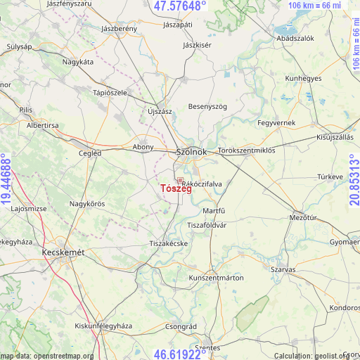
Tószeg GPS coordinates[2]
47° 6' 0" North, 20° 9' 0" East
| Map corner | latitude | longitude |
|---|---|---|
| Upper-left | 47.57648°, | 19.44688° |
| Center: | 47.1°, | 20.15° |
| Lower-right: | 46.61922°, | 20.85313° |
| Map W x H: | 106.4×106.4 km | = 66.1×66.1mi |
| max Lat: | 48.46667° ⇑65.8% North |
| Tószeg: | 47.1° |
| min Lat: | ⇓34.2% South 45.79108° |
| min Long | Tószeg | max Long |
| 16.27358° | 20.15° | 22.68096° |
| W 65.1%⇐ | ⇒34.9% E |
Elevation
Elevation of Tószeg is 84 m = 276 ft, and this is 45.7 m = 150 ft below average elevation for this country.
| Max E: |
444 m = 1457 ft | 94.4% |
| Avg. | 129.7 m = 426 ft | |
| Tószeg | 84 m = 276 ft | |
Min E: |
71 m = 233 ft | 5.6% |
See also: Hungary elevation on elevation.city.
Geographical zone
Tószeg is located in North temperate zone (between Tropic of Cancer and the Arctic Circle). Distance of this North polar circle is 2164.1 km =1344.7 mi to North.| Distance of | km | miles | from Tószeg |
|---|---|---|---|
| North Pole | 4770 | 2963.9 | to North |
| Arctic Circle | 2164.1 | 1344.7 | to North |
| Tropic Cancer | 2631.1 | 1634.9 | to South |
| Equator | 5237 | 3254.1 | to South |


Nearby cities:
15 places around Tószeg: (largest is in red/bold)
• Abony
14.9 km =9.3 mi,  312°
312°
• Cibakháza
16 km =9.9 mi,  166°
166°
• Jászkarajenő
8.4 km =5.2 mi,  228°
228°
• Kengyel
14 km =8.7 mi,  97°
97°
• Kocsér
20.5 km =12.7 mi,  237°
237°
• Rákóczifalva
6.6 km =4.1 mi,  106°
106°
• Rákócziújfalu
9.6 km =6 mi, 112°
• Szajol
14.6 km =9.1 mi,  50°
50°
• Szolnok
10 km =6.2 mi,  22°
22°
• Tiszaföldvár
15 km =9.3 mi,  149°
149°
• Tiszakécske
18.9 km =11.7 mi,  190°
190°
• Tiszapüspöki
18.1 km =11.2 mi,  44°
44°
• Törtel
16.3 km =10.1 mi,  278°
278°
• Törökszentmiklós
22.2 km =13.8 mi,  65°
65°
• Zagyvarékas
18.6 km =11.6 mi,  356°
356°
Sources, notices
• [Note1] Compared only with cities in Hungary existing in our database
• [Src1] Map data: © OpenStreetMap contributors (CC-BY-SA)
• [Src2] Other city data from geonames.org with taken over terms of usage.
• [Src3] Geographical zone / Annual Mean Temperature by Robert A. Rohde @ Wikipedia
