Tiszalúc geodata
Tiszalúc (Borsod-Abaúj-Zemplén) is a populated place; located in Hungary in Europe/Budapest (GMT+2) time zone. With population of 5,551 people, there are 274 cities with bigger population in this country. Compared to other cities in Hungary, 88.7% of cities are located further ↓South; 81.7% of cities are located further ←West and 65.5% of cities have higher elevation than Tiszalúc. Note1


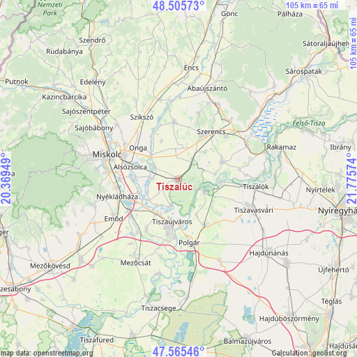
Tiszalúc GPS coordinates[2]
48° 2' 15.864" North, 21° 4' 21.396" East
| Map corner | latitude | longitude |
|---|---|---|
| Upper-left | 48.50573°, | 20.36949° |
| Center: | 48.03774°, | 21.07261° |
| Lower-right: | 47.56546°, | 21.77574° |
| Map W x H: | 104.5×104.5 km | = 64.9×64.9mi |
| max Lat: | 48.46667° ⇑11.3% North |
| Tiszalúc: | 48.03774° |
| min Lat: | ⇓88.7% South 45.79108° |
| min Long | Tiszalúc | max Long |
| 16.27358° | 21.07261° | 22.68096° |
| W 81.7%⇐ | ⇒18.3% E |
Elevation
Elevation of Tiszalúc is 106 m = 348 ft, and this is 23.7 m = 78 ft below average elevation for this country.
| Max E: |
444 m = 1457 ft | 65.5% |
| Avg. | 129.7 m = 426 ft | |
| Tiszalúc | 106 m = 348 ft | |
Min E: |
71 m = 233 ft | 34.5% |
See also: Hungary elevation on elevation.city.
Geographical zone
Tiszalúc is located in North temperate zone (between Tropic of Cancer and the Arctic Circle). Distance of this North polar circle is 2059.9 km =1280 mi to North.| Distance of | km | miles | from Tiszalúc |
|---|---|---|---|
| North Pole | 4665.8 | 2899.2 | to North |
| Arctic Circle | 2059.9 | 1280 | to North |
| Tropic Cancer | 2735.4 | 1699.7 | to South |
| Equator | 5341.3 | 3318.9 | to South |


Nearby cities:
15 places around Tiszalúc: (largest is in red/bold)
• Alsózsolca
14.7 km =9.1 mi,  284°
284°
• Bőcs
8 km =5 mi, 279°
• Gesztely
10.5 km =6.5 mi,  311°
311°
• Hernádnémeti
7.4 km =4.6 mi,  295°
295°
• Onga
14.5 km =9 mi, 307°
• Prügy
14.1 km =8.8 mi,  68°
68°
• Sajólád
12.9 km =8 mi, 276°
• Sajószöged
11.2 km =7 mi,  208°
208°
• Sajóörös
10.2 km =6.3 mi,  196°
196°
• Taktaharkány
6.8 km =4.2 mi,  41°
41°
• Taktaszada
12 km =7.5 mi, 43°
• Tiszadada
13.2 km =8.2 mi,  92°
92°
• Tiszadob
7.4 km =4.6 mi,  108°
108°
• Tiszaújváros
11.6 km =7.2 mi,  176°
176°
• Ónod
12.3 km =7.6 mi,  250°
250°
Sources, notices
• [Note1] Compared only with cities in Hungary existing in our database
• [Src1] Map data: © OpenStreetMap contributors (CC-BY-SA)
• [Src2] Other city data from geonames.org with taken over terms of usage.
• [Src3] Geographical zone / Annual Mean Temperature by Robert A. Rohde @ Wikipedia
