Szikszó geodata
Szikszó (Borsod-Abaúj-Zemplén) is a seat of a second-order administrative division; located in Hungary in Europe/Budapest (GMT+2) time zone. With population of 5,963 people, there are 258 cities with bigger population in this country. Compared to other cities in Hungary, 96% of cities are located further ↓South; 79.2% of cities are located further ←West and 50.8% of cities have higher elevation than Szikszó. Note1


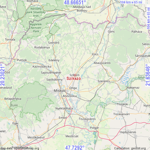
Szikszó GPS coordinates[2]
48° 12' 0" North, 20° 55' 59.988" East
| Map corner | latitude | longitude |
|---|---|---|
| Upper-left | 48.66651°, | 20.23021° |
| Center: | 48.2°, | 20.93333° |
| Lower-right: | 47.7292°, | 21.63646° |
| Map W x H: | 104.2×104.2 km | = 64.7×64.7mi |
| max Lat: | 48.46667° ⇑4% North |
| Szikszó: | 48.2° |
| min Lat: | ⇓96% South 45.79108° |
| min Long | Szikszó | max Long |
| 16.27358° | 20.93333° | 22.68096° |
| W 79.2%⇐ | ⇒20.8% E |
Elevation
Elevation of Szikszó is 115 m = 377 ft, and this is 14.7 m = 48 ft below average elevation for this country.
| Max E: |
444 m = 1457 ft | 50.8% |
| Avg. | 129.7 m = 426 ft | |
| Szikszó | 115 m = 377 ft | |
Min E: |
71 m = 233 ft | 49.2% |
See also: Hungary elevation on elevation.city.
Geographical zone
Szikszó is located in North temperate zone (between Tropic of Cancer and the Arctic Circle). Distance of this North polar circle is 2041.8 km =1268.7 mi to North.| Distance of | km | miles | from Szikszó |
|---|---|---|---|
| North Pole | 4647.7 | 2887.9 | to North |
| Arctic Circle | 2041.8 | 1268.7 | to North |
| Tropic Cancer | 2753.4 | 1710.9 | to South |
| Equator | 5359.3 | 3330.1 | to South |


Nearby cities:
15 places around Szikszó: (largest is in red/bold)
• Alsózsolca
15 km =9.3 mi,  195°
195°
• Arnót
9.5 km =5.9 mi,  215°
215°
• Aszaló
3.1 km =1.9 mi,  53°
53°
• Boldva
10.1 km =6.3 mi,  280°
280°
• Felsőzsolca
12.2 km =7.6 mi, 203°
• Gesztely
11.4 km =7.1 mi,  167°
167°
• Halmaj
7.4 km =4.6 mi,  41°
41°
• Hernádnémeti
15.3 km =9.5 mi, 165°
• Megyaszó
8.8 km =5.5 mi,  102°
102°
• Miskolc
15.7 km =9.8 mi,  225°
225°
• Monok
16.1 km =10 mi,  85°
85°
• Onga
9.3 km =5.8 mi,  187°
187°
• Sajóbábony
15.3 km =9.5 mi,  255°
255°
• Sajóvámos
7.8 km =4.8 mi,  254°
254°
• Szirmabesenyő
11.3 km =7 mi,  240°
240°
Sources, notices
• [Note1] Compared only with cities in Hungary existing in our database
• [Src1] Map data: © OpenStreetMap contributors (CC-BY-SA)
• [Src2] Other city data from geonames.org with taken over terms of usage.
• [Src3] Geographical zone / Annual Mean Temperature by Robert A. Rohde @ Wikipedia
