Boldva geodata
Boldva (Borsod-Abaúj-Zemplén) is a populated place; located in Hungary in Europe/Budapest (GMT+2) time zone. With population of 2,456 people, there are 629 cities with bigger population in this country. Compared to other cities in Hungary, 96.4% of cities are located further ↓South; 76.6% of cities are located further ←West and 54.3% of cities have lower elevation than Boldva. Note1


Boldva GPS coordinates[2]
48° 13' 0.012" North, 20° 48' 0" East
| Map corner | latitude | longitude |
|---|---|---|
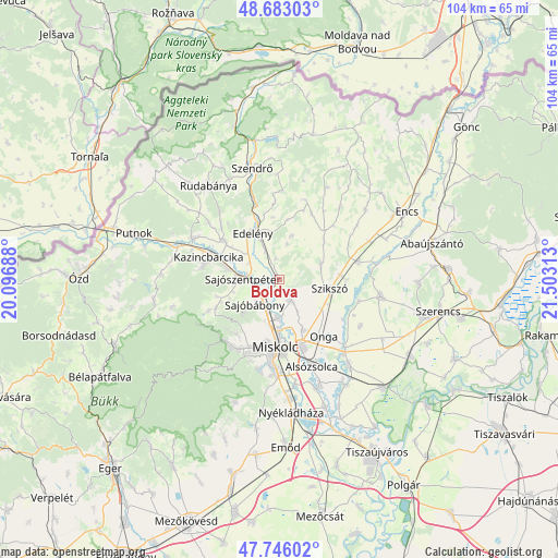
| Upper-left | 48.68303°, | 20.09688° |
| Center: | 48.21667°, | 20.8° |
| Lower-right: | 47.74602°, | 21.50313° |
| Map W x H: | 104.2×104.2 km | = 64.7×64.7mi |
| max Lat: | 48.46667° ⇑3.6% North |
| Boldva: | 48.21667° |
| min Lat: | ⇓96.4% South 45.79108° |
| min Long | Boldva | max Long |
| 16.27358° | 20.8° | 22.68096° |
| W 76.6%⇐ | ⇒23.4% E |
Elevation
Elevation of Boldva is 120 m = 394 ft, and this is 9.7 m = 32 ft below average elevation for this country.
| Max E: |
444 m = 1457 ft | 45.7% |
| Avg. | 129.7 m = 426 ft | |
| Boldva | 120 m = 394 ft | |
Min E: |
71 m = 233 ft | 54.3% |
See also: Hungary elevation on elevation.city.
Geographical zone
Boldva is located in North temperate zone (between Tropic of Cancer and the Arctic Circle). Distance of this North polar circle is 2040 km =1267.6 mi to North.| Distance of | km | miles | from Boldva |
|---|---|---|---|
| North Pole | 4645.9 | 2886.8 | to North |
| Arctic Circle | 2040 | 1267.6 | to North |
| Tropic Cancer | 2755.3 | 1712.1 | to South |
| Equator | 5361.2 | 3331.3 | to South |


Nearby cities:
15 places around Boldva: (largest is in red/bold)
• Arnót
10.5 km =6.5 mi,  155°
155°
• Aszaló
12.3 km =7.6 mi,  90°
90°
• Edelény
10.5 km =6.5 mi,  331°
331°
• Felsőzsolca
13.9 km =8.6 mi, 159°
• Halmaj
15.3 km =9.5 mi,  75°
75°
• Izsófalva
13.5 km =8.4 mi,  313°
313°
• Kazincbarcika
12.9 km =8 mi,  286°
286°
• Miskolc
13 km =8.1 mi,  185°
185°
• Múcsony
10.3 km =6.4 mi,  302°
302°
• Onga
14.1 km =8.8 mi,  142°
142°
• Sajóbábony
7.4 km =4.6 mi,  221°
221°
• Sajószentpéter
6.2 km =3.9 mi,  270°
270°
• Sajóvámos
4.5 km =2.8 mi,  149°
149°
• Szikszó
10.1 km =6.3 mi,  100°
100°
• Szirmabesenyő
7.4 km =4.6 mi,  180°
180°
Sources, notices
• [Note1] Compared only with cities in Hungary existing in our database
• [Src1] Map data: © OpenStreetMap contributors (CC-BY-SA)
• [Src2] Other city data from geonames.org with taken over terms of usage.
• [Src3] Geographical zone / Annual Mean Temperature by Robert A. Rohde @ Wikipedia
