Kocsord geodata
Kocsord (Szabolcs-Szatmár-Bereg) is a populated place; located in Hungary in Europe/Budapest (GMT+2) time zone. With population of 3,054 people, there are 487 cities with bigger population in this country. Compared to other cities in Hungary, 84.7% of cities are located further ↓South; 99.1% of cities are located further ←West and 56.5% of cities have higher elevation than Kocsord. Note1


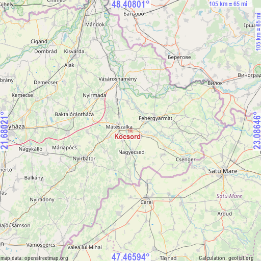
Kocsord GPS coordinates[2]
47° 56' 20.832" North, 22° 22' 59.988" East
| Map corner | latitude | longitude |
|---|---|---|
| Upper-left | 48.40801°, | 21.68021° |
| Center: | 47.93912°, | 22.38333° |
| Lower-right: | 47.46594°, | 23.08646° |
| Map W x H: | 104.7×104.7 km | = 65.1×65.1mi |
| max Lat: | 48.46667° ⇑15.3% North |
| Kocsord: | 47.93912° |
| min Lat: | ⇓84.7% South 45.79108° |
| min Long | Kocsord | max Long |
| 16.27358° | 22.38333° | 22.68096° |
| W 99.1%⇐ | ⇒0.90000000000001% E |
Elevation
Elevation of Kocsord is 112 m = 367 ft, and this is 17.7 m = 58 ft below average elevation for this country.
| Max E: |
444 m = 1457 ft | 56.5% |
| Avg. | 129.7 m = 426 ft | |
| Kocsord | 112 m = 367 ft | |
Min E: |
71 m = 233 ft | 43.5% |
See also: Hungary elevation on elevation.city.
Geographical zone
Kocsord is located in North temperate zone (between Tropic of Cancer and the Arctic Circle). Distance of this North polar circle is 2070.8 km =1286.7 mi to North.| Distance of | km | miles | from Kocsord |
|---|---|---|---|
| North Pole | 4676.7 | 2906 | to North |
| Arctic Circle | 2070.8 | 1286.7 | to North |
| Tropic Cancer | 2724.4 | 1692.9 | to South |
| Equator | 5330.3 | 3312.1 | to South |


Nearby cities:
15 places around Kocsord: (largest is in red/bold)
• Fehérgyarmat
11.1 km =6.9 mi,  63°
63°
• Hodász
13.7 km =8.5 mi,  260°
260°
• Kántorjánosi
17.4 km =10.8 mi,  267°
267°
• Mátészalka
4.8 km =3 mi,  291°
291°
• Mérk
16.8 km =10.4 mi,  180°
180°
• Nagydobos
14.4 km =8.9 mi,  335°
335°
• Nagyecsed
8.2 km =5.1 mi, 175°
• Nyírcsaholy
5.3 km =3.3 mi,  221°
221°
• Nyírmeggyes
9 km =5.6 mi,  253°
253°
• Porcsalma
15 km =9.3 mi,  114°
114°
• Szamosszeg
11.9 km =7.4 mi,  353°
353°
• Tunyogmatolcs
6.9 km =4.3 mi, 63°
• Tyukod
16.4 km =10.2 mi,  125°
125°
• Ópályi
7.8 km =4.8 mi,  326°
326°
• Ököritófülpös
9.6 km =6 mi,  103°
103°
Sources, notices
• [Note1] Compared only with cities in Hungary existing in our database
• [Src1] Map data: © OpenStreetMap contributors (CC-BY-SA)
• [Src2] Other city data from geonames.org with taken over terms of usage.
• [Src3] Geographical zone / Annual Mean Temperature by Robert A. Rohde @ Wikipedia
