Nagydobos geodata
Nagydobos (Szabolcs-Szatmár-Bereg) is a populated place; located in Hungary in Europe/Budapest (GMT+2) time zone. With population of 2,282 people, there are 679 cities with bigger population in this country. Compared to other cities in Hungary, 89.9% of cities are located further ↓South; 98.3% of cities are located further ←West and 50.7% of cities have lower elevation than Nagydobos. Note1


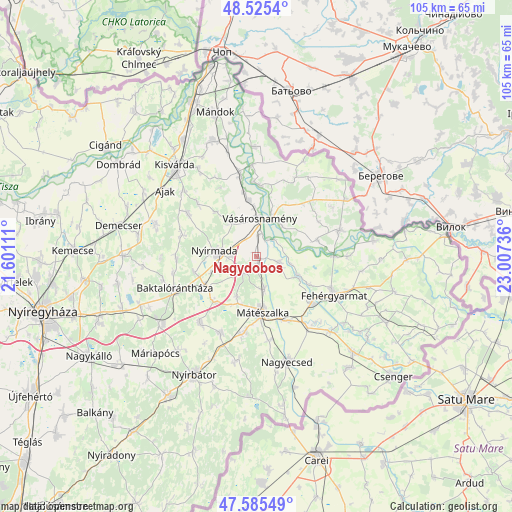
Nagydobos GPS coordinates[2]
48° 3' 27.324" North, 22° 18' 15.228" East
| Map corner | latitude | longitude |
|---|---|---|
| Upper-left | 48.5254°, | 21.60111° |
| Center: | 48.05759°, | 22.30423° |
| Lower-right: | 47.58549°, | 23.00736° |
| Map W x H: | 104.5×104.5 km | = 64.9×64.9mi |
| max Lat: | 48.46667° ⇑10.1% North |
| Nagydobos: | 48.05759° |
| min Lat: | ⇓89.9% South 45.79108° |
| min Long | Nagydobos | max Long |
| 16.27358° | 22.30423° | 22.68096° |
| W 98.3%⇐ | ⇒1.7% E |
Elevation
Elevation of Nagydobos is 116 m = 381 ft, and this is 13.7 m = 45 ft below average elevation for this country.
| Max E: |
444 m = 1457 ft | 49.3% |
| Avg. | 129.7 m = 426 ft | |
| Nagydobos | 116 m = 381 ft | |
Min E: |
71 m = 233 ft | 50.7% |
See also: Hungary elevation on elevation.city.
Geographical zone
Nagydobos is located in North temperate zone (between Tropic of Cancer and the Arctic Circle). Distance of this North polar circle is 2057.7 km =1278.6 mi to North.| Distance of | km | miles | from Nagydobos |
|---|---|---|---|
| North Pole | 4663.6 | 2897.8 | to North |
| Arctic Circle | 2057.7 | 1278.6 | to North |
| Tropic Cancer | 2737.6 | 1701.1 | to South |
| Equator | 5343.5 | 3320.3 | to South |


Nearby cities:
15 places around Nagydobos: (largest is in red/bold)
• Aranyosapáti
16.8 km =10.4 mi,  348°
348°
• Gyulaháza
16.3 km =10.1 mi,  301°
301°
• Hodász
17.3 km =10.7 mi,  206°
206°
• Kocsord
14.4 km =8.9 mi,  155°
155°
• Mátészalka
11.5 km =7.1 mi,  172°
172°
• Nyírcsaholy
17.3 km =10.7 mi, 172°
• Nyírkarász
15.4 km =9.6 mi,  285°
285°
• Nyírmada
7.8 km =4.8 mi,  277°
277°
• Nyírmeggyes
15.9 km =9.9 mi,  190°
190°
• Petneháza
17.1 km =10.6 mi,  271°
271°
• Szamosszeg
4.8 km =3 mi,  106°
106°
• Tunyogmatolcs
15.8 km =9.8 mi,  129°
129°
• Vaja
11.7 km =7.3 mi,  240°
240°
• Vásárosnamény
7.6 km =4.7 mi,  5°
5°
• Ópályi
6.9 km =4.3 mi, 166°
Sources, notices
• [Note1] Compared only with cities in Hungary existing in our database
• [Src1] Map data: © OpenStreetMap contributors (CC-BY-SA)
• [Src2] Other city data from geonames.org with taken over terms of usage.
• [Src3] Geographical zone / Annual Mean Temperature by Robert A. Rohde @ Wikipedia
