Mátészalka geodata
Mátészalka (Szabolcs-Szatmár-Bereg) is a seat of a second-order administrative division; located in Hungary in Europe/Budapest (GMT+2) time zone. With population of 18,718 people, there are 89 cities with bigger population in this country. Compared to other cities in Hungary, 85.5% of cities are located further ↓South; 98.5% of cities are located further ←West and 58.3% of cities have lower elevation than Mátészalka. Note1


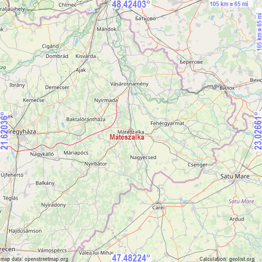
Mátészalka GPS coordinates[2]
47° 57' 19.008" North, 22° 19' 24.528" East
| Map corner | latitude | longitude |
|---|---|---|
| Upper-left | 48.42403°, | 21.62036° |
| Center: | 47.95528°, | 22.32348° |
| Lower-right: | 47.48224°, | 23.02661° |
| Map W x H: | 104.7×104.7 km | = 65.1×65.1mi |
| max Lat: | 48.46667° ⇑14.5% North |
| Mátészalka: | 47.95528° |
| min Lat: | ⇓85.5% South 45.79108° |
| min Long | Mátészalka | max Long |
| 16.27358° | 22.32348° | 22.68096° |
| W 98.5%⇐ | ⇒1.5% E |
Elevation
Elevation of Mátészalka is 124 m = 407 ft, and this is 5.7 m = 19 ft below average elevation for this country.
| Max E: |
444 m = 1457 ft | 41.7% |
| Avg. | 129.7 m = 426 ft | |
| Mátészalka | 124 m = 407 ft | |
Min E: |
71 m = 233 ft | 58.3% |
See also: Hungary elevation on elevation.city.
Geographical zone
Mátészalka is located in North temperate zone (between Tropic of Cancer and the Arctic Circle). Distance of this North polar circle is 2069 km =1285.6 mi to North.| Distance of | km | miles | from Mátészalka |
|---|---|---|---|
| North Pole | 4674.9 | 2904.8 | to North |
| Arctic Circle | 2069 | 1285.6 | to North |
| Tropic Cancer | 2726.2 | 1694 | to South |
| Equator | 5332.1 | 3313.2 | to South |


Nearby cities:
15 places around Mátészalka: (largest is in red/bold)
• Fehérgyarmat
14.7 km =9.1 mi,  77°
77°
• Hodász
10 km =6.2 mi,  245°
245°
• Kocsord
4.8 km =3 mi,  111°
111°
• Kántorjánosi
13.1 km =8.1 mi,  259°
259°
• Nagydobos
11.5 km =7.1 mi,  352°
352°
• Nagyecsed
11.2 km =7 mi,  153°
153°
• Nyírcsaholy
5.8 km =3.6 mi,  170°
170°
• Nyírmada
15.4 km =9.6 mi,  323°
323°
• Nyírmeggyes
6 km =3.7 mi,  224°
224°
• Nyírvasvári
18.5 km =11.5 mi,  213°
213°
• Szamosszeg
10.5 km =6.5 mi,  17°
17°
• Tunyogmatolcs
10.7 km =6.6 mi, 83°
• Vaja
12.9 km =8 mi,  295°
295°
• Ópályi
4.7 km =2.9 mi,  2°
2°
• Ököritófülpös
14.3 km =8.9 mi, 106°
Sources, notices
• [Note1] Compared only with cities in Hungary existing in our database
• [Src1] Map data: © OpenStreetMap contributors (CC-BY-SA)
• [Src2] Other city data from geonames.org with taken over terms of usage.
• [Src3] Geographical zone / Annual Mean Temperature by Robert A. Rohde @ Wikipedia
