Kék geodata
Kék (Szabolcs-Szatmár-Bereg) is a populated place; located in Hungary in Europe/Budapest (GMT+2) time zone. With population of 2,044 people, there are 761 cities with bigger population in this country. Compared to other cities in Hungary, 92.2% of cities are located further ↓South; 92.6% of cities are located further ←West and 77% of cities have higher elevation than Kék. Note1


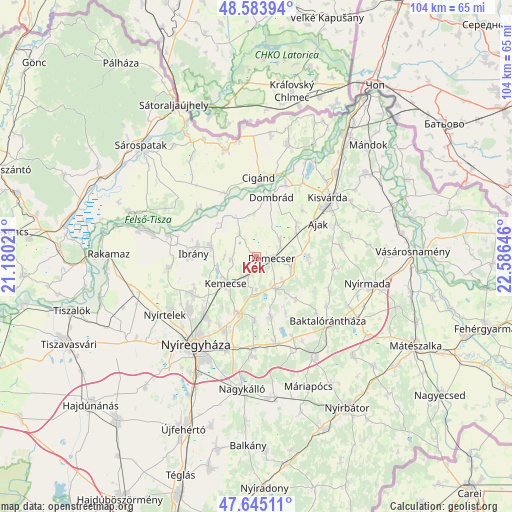
Kék GPS coordinates[2]
48° 7' 0.012" North, 21° 52' 59.988" East
| Map corner | latitude | longitude |
|---|---|---|
| Upper-left | 48.58394°, | 21.18021° |
| Center: | 48.11667°, | 21.88333° |
| Lower-right: | 47.64511°, | 22.58646° |
| Map W x H: | 104.4×104.4 km | = 64.9×64.9mi |
| max Lat: | 48.46667° ⇑7.8% North |
| Kék: | 48.11667° |
| min Lat: | ⇓92.2% South 45.79108° |
| min Long | Kék | max Long |
| 16.27358° | 21.88333° | 22.68096° |
| W 92.6%⇐ | ⇒7.4% E |
Elevation
Elevation of Kék is 97 m = 318 ft, and this is 32.7 m = 107 ft below average elevation for this country.
| Max E: |
444 m = 1457 ft | 77% |
| Avg. | 129.7 m = 426 ft | |
| Kék | 97 m = 318 ft | |
Min E: |
71 m = 233 ft | 23% |
See also: Hungary elevation on elevation.city.
Geographical zone
Kék is located in North temperate zone (between Tropic of Cancer and the Arctic Circle). Distance of this North polar circle is 2051.1 km =1274.5 mi to North.| Distance of | km | miles | from Kék |
|---|---|---|---|
| North Pole | 4657 | 2893.7 | to North |
| Arctic Circle | 2051.1 | 1274.5 | to North |
| Tropic Cancer | 2744.2 | 1705.2 | to South |
| Equator | 5350.1 | 3324.4 | to South |


Nearby cities:
15 places around Kék: (largest is in red/bold)
• Ajak
14.9 km =9.3 mi,  63°
63°
• Cigánd
15.5 km =9.6 mi,  2°
2°
• Demecser
3.2 km =2 mi,  90°
90°
• Dombrád
13.5 km =8.4 mi,  15°
15°
• Gégény
6.2 km =3.9 mi,  53°
53°
• Ibrány
12.9 km =8 mi,  273°
273°
• Kemecse
7.3 km =4.5 mi,  231°
231°
• Kótaj
14.4 km =8.9 mi,  239°
239°
• Nagyhalász
9.2 km =5.7 mi,  281°
281°
• Nyírbogdány
6.6 km =4.1 mi,  180°
180°
• Nyírtass
11.1 km =6.9 mi, 90°
• Petneháza
15.5 km =9.6 mi,  113°
113°
• Pátroha
10.3 km =6.4 mi, 57°
• Tiszakarád
15.4 km =9.6 mi,  306°
306°
• Újdombrád
8.8 km =5.5 mi,  353°
353°
Sources, notices
• [Note1] Compared only with cities in Hungary existing in our database
• [Src1] Map data: © OpenStreetMap contributors (CC-BY-SA)
• [Src2] Other city data from geonames.org with taken over terms of usage.
• [Src3] Geographical zone / Annual Mean Temperature by Robert A. Rohde @ Wikipedia
