Tiszakarád geodata
Tiszakarád (Borsod-Abaúj-Zemplén) is a populated place; located in Hungary in Europe/Budapest (GMT+2) time zone. With population of 2,522 people, there are 610 cities with bigger population in this country. Compared to other cities in Hungary, 96% of cities are located further ↓South; 90.6% of cities are located further ←West and 77% of cities have higher elevation than Tiszakarád. Note1


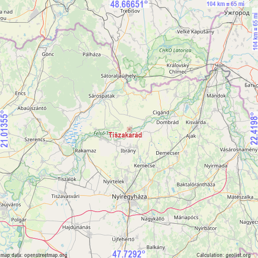
Tiszakarád GPS coordinates[2]
48° 12' 0" North, 21° 43' 0.012" East
| Map corner | latitude | longitude |
|---|---|---|
| Upper-left | 48.66651°, | 21.01355° |
| Center: | 48.2°, | 21.71667° |
| Lower-right: | 47.7292°, | 22.4198° |
| Map W x H: | 104.2×104.2 km | = 64.7×64.7mi |
| max Lat: | 48.46667° ⇑4% North |
| Tiszakarád: | 48.2° |
| min Lat: | ⇓96% South 45.79108° |
| min Long | Tiszakarád | max Long |
| 16.27358° | 21.71667° | 22.68096° |
| W 90.6%⇐ | ⇒9.4% E |
Elevation
Elevation of Tiszakarád is 97 m = 318 ft, and this is 32.7 m = 107 ft below average elevation for this country.
| Max E: |
444 m = 1457 ft | 77% |
| Avg. | 129.7 m = 426 ft | |
| Tiszakarád | 97 m = 318 ft | |
Min E: |
71 m = 233 ft | 23% |
See also: Hungary elevation on elevation.city.
Geographical zone
Tiszakarád is located in North temperate zone (between Tropic of Cancer and the Arctic Circle). Distance of this North polar circle is 2041.8 km =1268.7 mi to North.| Distance of | km | miles | from Tiszakarád |
|---|---|---|---|
| North Pole | 4647.7 | 2887.9 | to North |
| Arctic Circle | 2041.8 | 1268.7 | to North |
| Tropic Cancer | 2753.4 | 1710.9 | to South |
| Equator | 5359.3 | 3330.1 | to South |


Nearby cities:
15 places around Tiszakarád: (largest is in red/bold)
• Buj
12.2 km =7.6 mi,  203°
203°
• Cigánd
14.4 km =8.9 mi,  64°
64°
• Demecser
18.1 km =11.2 mi,  120°
120°
• Dombrád
16.5 km =10.3 mi,  76°
76°
• Gégény
18.2 km =11.3 mi,  107°
107°
• Ibrány
8.5 km =5.3 mi,  183°
183°
• Karcsa
14 km =8.7 mi,  27°
27°
• Kemecse
15.4 km =9.6 mi,  154°
154°
• Kék
15.4 km =9.6 mi,  126°
126°
• Kótaj
16.7 km =10.4 mi, 180°
• Nagyhalász
8.2 km =5.1 mi,  156°
156°
• Nyírbogdány
20.1 km =12.5 mi,  142°
142°
• Sárospatak
17.4 km =10.8 mi,  322°
322°
• Tiszabercel
7.4 km =4.6 mi,  221°
221°
• Újdombrád
11.4 km =7.1 mi,  92°
92°
Sources, notices
• [Note1] Compared only with cities in Hungary existing in our database
• [Src1] Map data: © OpenStreetMap contributors (CC-BY-SA)
• [Src2] Other city data from geonames.org with taken over terms of usage.
• [Src3] Geographical zone / Annual Mean Temperature by Robert A. Rohde @ Wikipedia
