Kardos geodata
Kardos (Csongrád) is a section of populated place; located in Hungary in Europe/Budapest (GMT+2) time zone. With population of 682 people, there are 882 cities with bigger population in this country. Compared to other cities in Hungary, 94.4% of cities are located further ↑North; 73.2% of cities are located further ←West and 93.3% of cities have higher elevation than Kardos. Note1


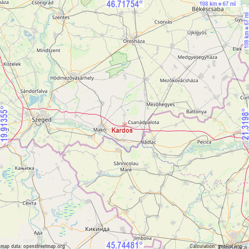
Kardos GPS coordinates[2]
46° 13' 59.988" North, 20° 37' 0.012" East
| Map corner | latitude | longitude |
|---|---|---|
| Upper-left | 46.71754°, | 19.91355° |
| Center: | 46.23333°, | 20.61667° |
| Lower-right: | 45.74481°, | 21.3198° |
| Map W x H: | 108.2×108.2 km | = 67.2×67.2mi |
| max Lat: | 48.46667° ⇑94.4% North |
| Kardos: | 46.23333° |
| min Lat: | ⇓5.6% South 45.79108° |
| min Long | Kardos | max Long |
| 16.27358° | 20.61667° | 22.68096° |
| W 73.2%⇐ | ⇒26.8% E |
Elevation
Elevation of Kardos is 85 m = 279 ft, and this is 44.7 m = 147 ft below average elevation for this country.
| Max E: |
444 m = 1457 ft | 93.3% |
| Avg. | 129.7 m = 426 ft | |
| Kardos | 85 m = 279 ft | |
Min E: |
71 m = 233 ft | 6.7% |
See also: Hungary elevation on elevation.city.
Geographical zone
Kardos is located in North temperate zone (between Tropic of Cancer and the Arctic Circle). Distance of this North polar circle is 2260.5 km =1404.6 mi to North.| Distance of | km | miles | from Kardos |
|---|---|---|---|
| North Pole | 4866.4 | 3023.8 | to North |
| Arctic Circle | 2260.5 | 1404.6 | to North |
| Tropic Cancer | 2534.7 | 1575 | to South |
| Equator | 5140.7 | 3194.3 | to South |


Nearby cities:
15 places around Kardos: (largest is in red/bold)
• Ambrózfalva
15.8 km =9.8 mi,  34°
34°
• Apátfalva
7.8 km =4.8 mi,  199°
199°
• Békéssámson
20.4 km =12.7 mi,  3°
3°
• Csanádpalota
9.2 km =5.7 mi,  78°
78°
• Deszk
28.8 km =17.9 mi,  266°
266°
• Földeák
12.9 km =8 mi,  315°
315°
• Hódmezővásárhely
29.8 km =18.5 mi,  313°
313°
• Kaszaper
30.8 km =19.1 mi, 32°
• Kiszombor
15.2 km =9.4 mi,  248°
248°
• Makó
10.4 km =6.5 mi,  259°
259°
• Maroslele
20.8 km =12.9 mi,  280°
280°
• Mezőhegyes
17.9 km =11.1 mi,  58°
58°
• Mezőkovácsháza
29.6 km =18.4 mi,  51°
51°
• Székkutas
30.3 km =18.8 mi,  347°
347°
• Tótkomlós
22.3 km =13.9 mi,  23°
23°
Sources, notices
• [Note1] Compared only with cities in Hungary existing in our database
• [Src1] Map data: © OpenStreetMap contributors (CC-BY-SA)
• [Src2] Other city data from geonames.org with taken over terms of usage.
• [Src3] Geographical zone / Annual Mean Temperature by Robert A. Rohde @ Wikipedia
