Kállósemjén geodata
Kállósemjén (Szabolcs-Szatmár-Bereg) is a populated place; located in Hungary in Europe/Budapest (GMT+2) time zone. With population of 3,968 people, there are 381 cities with bigger population in this country. Compared to other cities in Hungary, 80.8% of cities are located further ↓South; 93.7% of cities are located further ←West and 68.2% of cities have lower elevation than Kállósemjén. Note1


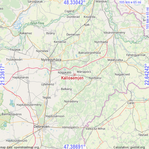
Kállósemjén GPS coordinates[2]
47° 51' 38.916" North, 21° 56' 21.444" East
| Map corner | latitude | longitude |
|---|---|---|
| Upper-left | 48.33042°, | 21.23617° |
| Center: | 47.86081°, | 21.93929° |
| Lower-right: | 47.38691°, | 22.64242° |
| Map W x H: | 104.9×104.9 km | = 65.2×65.2mi |
| max Lat: | 48.46667° ⇑19.2% North |
| Kállósemjén: | 47.86081° |
| min Lat: | ⇓80.8% South 45.79108° |
| min Long | Kállósemjén | max Long |
| 16.27358° | 21.93929° | 22.68096° |
| W 93.7%⇐ | ⇒6.3% E |
Elevation
Elevation of Kállósemjén is 135 m = 443 ft, and this is 5.3 m = 17 ft above average elevation for this country.
| Max E: |
444 m = 1457 ft | 31.8% |
| Kállósemjén | 135 m 443 ft | |
| Avg. | 129.7 m = 426 ft | |
Min E: |
71 m = 233 ft | 68.2% |
See also: Hungary elevation on elevation.city.
Geographical zone
Kállósemjén is located in North temperate zone (between Tropic of Cancer and the Arctic Circle). Distance of this North polar circle is 2079.6 km =1292.2 mi to North.| Distance of | km | miles | from Kállósemjén |
|---|---|---|---|
| North Pole | 4685.4 | 2911.4 | to North |
| Arctic Circle | 2079.6 | 1292.2 | to North |
| Tropic Cancer | 2715.7 | 1687.5 | to South |
| Equator | 5321.6 | 3306.7 | to South |


Nearby cities:
15 places around Kállósemjén: (largest is in red/bold)
• Apagy
11.5 km =7.1 mi,  358°
358°
• Balkány
11.5 km =7.1 mi,  209°
209°
• Kisléta
5.2 km =3.2 mi,  112°
112°
• Kántorjánosi
17.7 km =11 mi,  62°
62°
• Levelek
11.9 km =7.4 mi,  16°
16°
• Máriapócs
6.9 km =4.3 mi,  68°
68°
• Nagykálló
7.5 km =4.7 mi,  282°
282°
• Napkor
10.1 km =6.3 mi,  328°
328°
• Nyírbogát
11.4 km =7.1 mi,  124°
124°
• Nyírbátor
14.8 km =9.2 mi,  101°
101°
• Nyírgyulaj
12.2 km =7.6 mi,  76°
76°
• Nyírmihálydi
13.6 km =8.5 mi,  172°
172°
• Nyírpazony
17.1 km =10.6 mi,  322°
322°
• Szakoly
10.6 km =6.6 mi,  189°
189°
• Ófehértó
11.5 km =7.1 mi,  45°
45°
Sources, notices
• [Note1] Compared only with cities in Hungary existing in our database
• [Src1] Map data: © OpenStreetMap contributors (CC-BY-SA)
• [Src2] Other city data from geonames.org with taken over terms of usage.
• [Src3] Geographical zone / Annual Mean Temperature by Robert A. Rohde @ Wikipedia
