Levelek geodata
Levelek (Szabolcs-Szatmár-Bereg) is a populated place; located in Hungary in Europe/Budapest (GMT+2) time zone. With population of 2,948 people, there are 509 cities with bigger population in this country. Compared to other cities in Hungary, 85.7% of cities are located further ↓South; 94.3% of cities are located further ←West and 55.3% of cities have lower elevation than Levelek. Note1


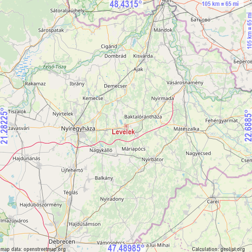
Levelek GPS coordinates[2]
47° 57' 46.152" North, 21° 59' 7.332" East
| Map corner | latitude | longitude |
|---|---|---|
| Upper-left | 48.4315°, | 21.28225° |
| Center: | 47.96282°, | 21.98537° |
| Lower-right: | 47.48985°, | 22.6885° |
| Map W x H: | 104.7×104.7 km | = 65.1×65.1mi |
| max Lat: | 48.46667° ⇑14.3% North |
| Levelek: | 47.96282° |
| min Lat: | ⇓85.7% South 45.79108° |
| min Long | Levelek | max Long |
| 16.27358° | 21.98537° | 22.68096° |
| W 94.3%⇐ | ⇒5.7% E |
Elevation
Elevation of Levelek is 121 m = 397 ft, and this is 8.7 m = 29 ft below average elevation for this country.
| Max E: |
444 m = 1457 ft | 44.7% |
| Avg. | 129.7 m = 426 ft | |
| Levelek | 121 m = 397 ft | |
Min E: |
71 m = 233 ft | 55.3% |
See also: Hungary elevation on elevation.city.
Geographical zone
Levelek is located in North temperate zone (between Tropic of Cancer and the Arctic Circle). Distance of this North polar circle is 2068.2 km =1285.1 mi to North.| Distance of | km | miles | from Levelek |
|---|---|---|---|
| North Pole | 4674.1 | 2904.4 | to North |
| Arctic Circle | 2068.2 | 1285.1 | to North |
| Tropic Cancer | 2727 | 1694.5 | to South |
| Equator | 5333 | 3313.8 | to South |


Nearby cities:
15 places around Levelek: (largest is in red/bold)
• Apagy
3.7 km =2.3 mi,  272°
272°
• Baktalórántháza
8.4 km =5.2 mi,  60°
60°
• Hodász
16.8 km =10.4 mi,  107°
107°
• Kisléta
13.5 km =8.4 mi,  174°
174°
• Kállósemjén
11.9 km =7.4 mi,  196°
196°
• Kántorjánosi
12.7 km =7.9 mi,  104°
104°
• Máriapócs
9.4 km =5.8 mi,  161°
161°
• Nagykálló
14.5 km =9 mi,  227°
227°
• Napkor
9.2 km =5.7 mi,  252°
252°
• Nyírbogdány
13 km =8.1 mi,  323°
323°
• Nyírgyulaj
11.9 km =7.4 mi,  135°
135°
• Nyírpazony
14 km =8.7 mi,  279°
279°
• Petneháza
12.8 km =8 mi,  31°
31°
• Vaja
14.4 km =8.9 mi,  70°
70°
• Ófehértó
5.8 km =3.6 mi,  124°
124°
Sources, notices
• [Note1] Compared only with cities in Hungary existing in our database
• [Src1] Map data: © OpenStreetMap contributors (CC-BY-SA)
• [Src2] Other city data from geonames.org with taken over terms of usage.
• [Src3] Geographical zone / Annual Mean Temperature by Robert A. Rohde @ Wikipedia
