Bagamér geodata
Bagamér (Hajdú-Bihar) is a populated place; located in Hungary in Europe/Budapest (GMT+2) time zone. With population of 2,433 people, there are 636 cities with bigger population in this country. Compared to other cities in Hungary, 52% of cities are located further ↓South; 94.4% of cities are located further ←West and 63% of cities have lower elevation than Bagamér. Note1


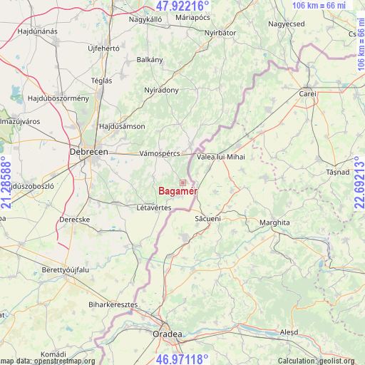
Bagamér GPS coordinates[2]
47° 26' 55.752" North, 21° 59' 20.4" East
| Map corner | latitude | longitude |
|---|---|---|
| Upper-left | 47.92216°, | 21.28588° |
| Center: | 47.44882°, | 21.989° |
| Lower-right: | 46.97118°, | 22.69213° |
| Map W x H: | 105.7×105.7 km | = 65.7×65.7mi |
| max Lat: | 48.46667° ⇑48% North |
| Bagamér: | 47.44882° |
| min Lat: | ⇓52% South 45.79108° |
| min Long | Bagamér | max Long |
| 16.27358° | 21.989° | 22.68096° |
| W 94.4%⇐ | ⇒5.6% E |
Elevation
Elevation of Bagamér is 129 m = 423 ft, and this is 0.69999999999999 m = 2 ft below average elevation for this country.
| Max E: |
444 m = 1457 ft | 37% |
| Avg. | 129.7 m = 426 ft | |
| Bagamér | 129 m = 423 ft | |
Min E: |
71 m = 233 ft | 63% |
See also: Hungary elevation on elevation.city.
Geographical zone
Bagamér is located in North temperate zone (between Tropic of Cancer and the Arctic Circle). Distance of this North polar circle is 2125.4 km =1320.7 mi to North.| Distance of | km | miles | from Bagamér |
|---|---|---|---|
| North Pole | 4731.2 | 2939.8 | to North |
| Arctic Circle | 2125.4 | 1320.7 | to North |
| Tropic Cancer | 2669.9 | 1659 | to South |
| Equator | 5275.8 | 3278.2 | to South |


Nearby cities:
15 places around Bagamér: (largest is in red/bold)
• Debrecen
28.3 km =17.6 mi,  289°
289°
• Hajdúbagos
25.1 km =15.6 mi,  255°
255°
• Hajdúsámson
23.7 km =14.7 mi,  315°
315°
• Hosszúpályi
20.2 km =12.6 mi,  252°
252°
• Létavértes
9.9 km =6.2 mi,  222°
222°
• Mikepércs
26.7 km =16.6 mi,  270°
270°
• Monostorpályi
16.4 km =10.2 mi, 250°
• Nyíracsád
17.2 km =10.7 mi,  355°
355°
• Nyíradony
28.1 km =17.5 mi,  349°
349°
• Nyírlugos
27.5 km =17.1 mi,  8°
8°
• Nyírmártonfalva
16.4 km =10.2 mi,  335°
335°
• Nyírábrány
11.9 km =7.4 mi, 12°
• Pocsaj
22.5 km =14 mi, 215°
• Sáránd
27.3 km =17 mi, 258°
• Vámospércs
11.5 km =7.1 mi, 324°
Sources, notices
• [Note1] Compared only with cities in Hungary existing in our database
• [Src1] Map data: © OpenStreetMap contributors (CC-BY-SA)
• [Src2] Other city data from geonames.org with taken over terms of usage.
• [Src3] Geographical zone / Annual Mean Temperature by Robert A. Rohde @ Wikipedia
